You are here: Home > Network List > N4 - Central and EAstern US Network Stations List
> Station V55A Morning Dew, Taylorsville, NC, USA > Earthquake Result Viewer
V55A Morning Dew, Taylorsville, NC, USA - Earthquake Result Viewer
| Earthquake location: |
Near East Coast Of Honshu, Japan |
| Earthquake latitude/longitude: |
37.7/142.0 |
| Earthquake time(UTC): |
2021/02/13 (044) 14:07:49 GMT |
| Earthquake Depth: |
54 km |
| Earthquake Magnitude: |
7.0 mww |
| Earthquake Catalog/Contributor: |
NEIC PDE/us |
|
| Network: |
N4 Central and EAstern US Network |
| Station: |
V55A Morning Dew, Taylorsville, NC, USA |
| Lat/Lon: |
35.85 N/81.21 W |
| Elevation: |
313 m |
|
| Distance: |
96.6 deg |
| Az: |
34.049 deg |
| Baz: |
326.854 deg |
| Ray Param: |
0.040436823 |
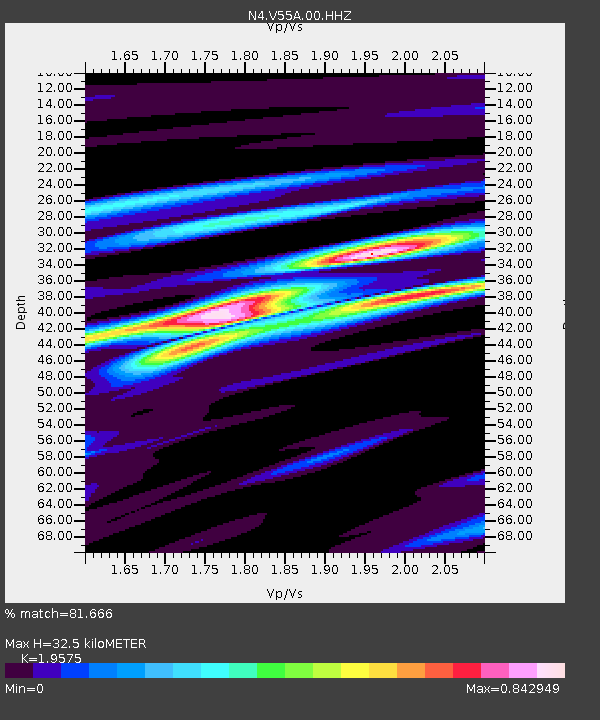
| Estimated Moho Depth: |
32.5 km |
| Estimated Crust Vp/Vs: |
1.96 |
| Assumed Crust Vp: |
6.419 km/s |
| Estimated Crust Vs: |
3.279 km/s |
| Estimated Crust Poisson's Ratio: |
0.32 |
|
| Radial Match: |
81.666 % |
| Radial Bump: |
375 |
| Transverse Match: |
52.793526 % |
| Transverse Bump: |
400 |
| SOD ConfigId: |
23341671 |
| Insert Time: |
2021-02-27 15:24:25.059 +0000 |
| GWidth: |
2.5 |
| Max Bumps: |
400 |
| Tol: |
0.001 |
|

Signal To Noise
| Channel | StoN | STA | LTA |
| N4:V55A:00:HHZ:20210213T14:20:42.239993Z | 2.2245462 | 8.986485E-7 | 4.0396938E-7 |
| N4:V55A:00:HH1:20210213T14:20:42.239993Z | 1.0015693 | 3.1065207E-7 | 3.1016535E-7 |
| N4:V55A:00:HH2:20210213T14:20:42.239993Z | 1.363028 | 4.3069582E-7 | 3.1598458E-7 |
| Arrivals |
| Ps | 4.9 SECOND |
| PpPs | 15 SECOND |
| PsPs/PpSs | 20 SECOND |


