You are here: Home > Network List > O2 - Oklahoma Consolidated Temporary Seismic Networks Stations List
> Station FW02 Waynoka, Oklahoma, USA > Earthquake Result Viewer
FW02 Waynoka, Oklahoma, USA - Earthquake Result Viewer
| Earthquake location: |
Near East Coast Of Honshu, Japan |
| Earthquake latitude/longitude: |
37.7/142.0 |
| Earthquake time(UTC): |
2021/02/13 (044) 14:07:49 GMT |
| Earthquake Depth: |
54 km |
| Earthquake Magnitude: |
7.0 mww |
| Earthquake Catalog/Contributor: |
NEIC PDE/us |
|
| Network: |
O2 Oklahoma Consolidated Temporary Seismic Networks |
| Station: |
FW02 Waynoka, Oklahoma, USA |
| Lat/Lon: |
36.38 N/98.73 W |
| Elevation: |
434 m |
|
| Distance: |
87.3 deg |
| Az: |
44.804 deg |
| Baz: |
316.151 deg |
| Ray Param: |
0.043304093 |
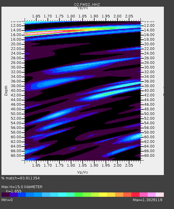
| Estimated Moho Depth: |
15.0 km |
| Estimated Crust Vp/Vs: |
1.65 |
| Assumed Crust Vp: |
6.426 km/s |
| Estimated Crust Vs: |
3.883 km/s |
| Estimated Crust Poisson's Ratio: |
0.21 |
|
| Radial Match: |
93.911354 % |
| Radial Bump: |
324 |
| Transverse Match: |
84.72092 % |
| Transverse Bump: |
400 |
| SOD ConfigId: |
23341671 |
| Insert Time: |
2021-02-27 15:25:47.061 +0000 |
| GWidth: |
2.5 |
| Max Bumps: |
400 |
| Tol: |
0.001 |
|

Signal To Noise
| Channel | StoN | STA | LTA |
| O2:FW02: :HHZ:20210213T14:19:59.59003Z | 2.118861 | 6.1466227E-7 | 2.900909E-7 |
| O2:FW02: :HHN:20210213T14:19:59.59003Z | 1.9866302 | 8.1268155E-7 | 4.090754E-7 |
| O2:FW02: :HHE:20210213T14:19:59.59003Z | 2.088367 | 6.8206566E-7 | 3.266024E-7 |
| Arrivals |
| Ps | 1.6 SECOND |
| PpPs | 6.1 SECOND |
| PsPs/PpSs | 7.6 SECOND |


