You are here: Home > Network List > O2 - Oklahoma Consolidated Temporary Seismic Networks Stations List
> Station GORE Near Medford, Oklahoma, USA > Earthquake Result Viewer
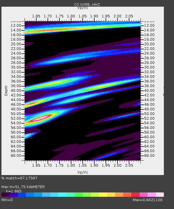
GORE Near Medford, Oklahoma, USA - Earthquake Result Viewer
| Earthquake location: |
Near East Coast Of Honshu, Japan |
| Earthquake latitude/longitude: |
37.7/142.0 |
| Earthquake time(UTC): |
2021/02/13 (044) 14:07:49 GMT |
| Earthquake Depth: |
54 km |
| Earthquake Magnitude: |
7.0 mww |
| Earthquake Catalog/Contributor: |
NEIC PDE/us |
|
| Network: |
O2 Oklahoma Consolidated Temporary Seismic Networks |
| Station: |
GORE Near Medford, Oklahoma, USA |
| Lat/Lon: |
36.79 N/97.95 W |
| Elevation: |
348 m |
|
| Distance: |
87.5 deg |
| Az: |
44.067 deg |
| Baz: |
316.582 deg |
| Ray Param: |
0.04320256 |
| Estimated Moho Depth: |
51.75 km |
| Estimated Crust Vp/Vs: |
1.66 |
| Assumed Crust Vp: |
6.483 km/s |
| Estimated Crust Vs: |
3.893 km/s |
| Estimated Crust Poisson's Ratio: |
0.22 |
|
| Radial Match: |
97.17597 % |
| Radial Bump: |
328 |
| Transverse Match: |
88.62329 % |
| Transverse Bump: |
344 |
| SOD ConfigId: |
23341671 |
| Insert Time: |
2021-02-27 15:25:55.266 +0000 |
| GWidth: |
2.5 |
| Max Bumps: |
400 |
| Tol: |
0.001 |
|

Signal To Noise
| Channel | StoN | STA | LTA |
| O2:GORE: :HHZ:20210213T14:20:00.265018Z | 2.343772 | 1.0350644E-6 | 4.4162337E-7 |
| O2:GORE: :HHN:20210213T14:20:00.265018Z | 1.3377187 | 4.059595E-7 | 3.034715E-7 |
| O2:GORE: :HHE:20210213T14:20:00.265018Z | 1.3578899 | 3.8293757E-7 | 2.820093E-7 |
| Arrivals |
| Ps | 5.4 SECOND |
| PpPs | 21 SECOND |
| PsPs/PpSs | 26 SECOND |


