You are here: Home > Network List > PE - Penn State Network Stations List
> Station PAGS PA Geological Survey, Middletown, PA > Earthquake Result Viewer
PAGS PA Geological Survey, Middletown, PA - Earthquake Result Viewer
| Earthquake location: |
Near East Coast Of Honshu, Japan |
| Earthquake latitude/longitude: |
37.7/142.0 |
| Earthquake time(UTC): |
2021/02/13 (044) 14:07:49 GMT |
| Earthquake Depth: |
54 km |
| Earthquake Magnitude: |
7.0 mww |
| Earthquake Catalog/Contributor: |
NEIC PDE/us |
|
| Network: |
PE Penn State Network |
| Station: |
PAGS PA Geological Survey, Middletown, PA |
| Lat/Lon: |
40.23 N/76.72 W |
| Elevation: |
120 m |
|
| Distance: |
94.7 deg |
| Az: |
28.714 deg |
| Baz: |
330.141 deg |
| Ray Param: |
0.040946394 |
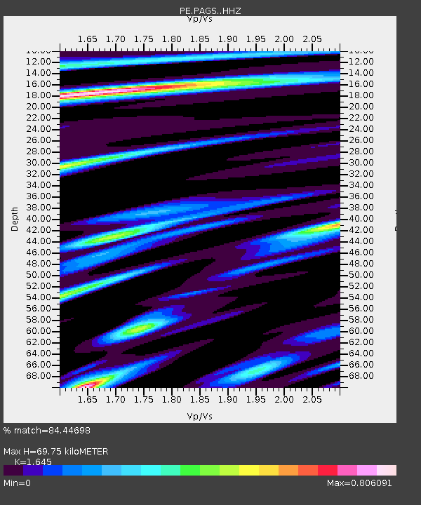
| Estimated Moho Depth: |
69.75 km |
| Estimated Crust Vp/Vs: |
1.64 |
| Assumed Crust Vp: |
6.121 km/s |
| Estimated Crust Vs: |
3.721 km/s |
| Estimated Crust Poisson's Ratio: |
0.21 |
|
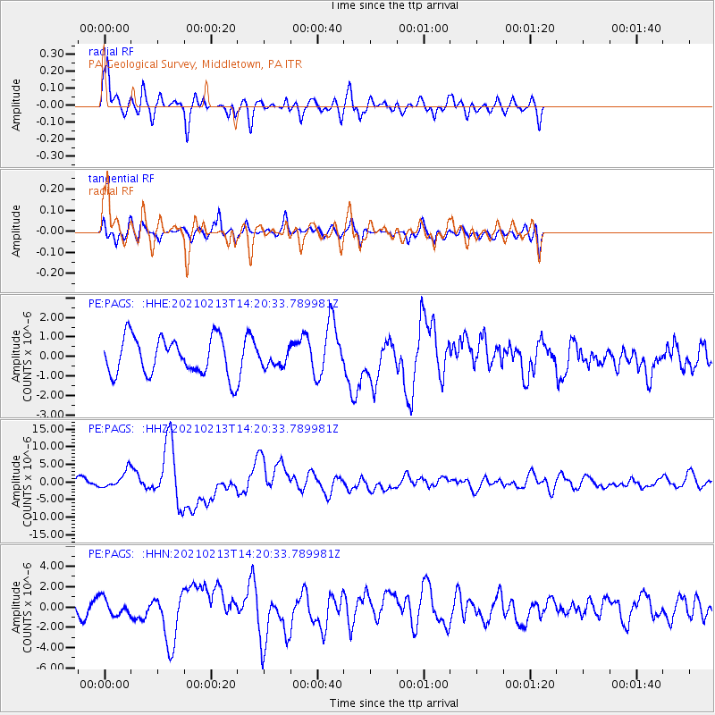
| Radial Match: |
84.44698 % |
| Radial Bump: |
400 |
| Transverse Match: |
46.65022 % |
| Transverse Bump: |
400 |
| SOD ConfigId: |
23341671 |
| Insert Time: |
2021-02-27 15:27:12.551 +0000 |
| GWidth: |
2.5 |
| Max Bumps: |
400 |
| Tol: |
0.001 |
|
Signal To Noise
| Channel | StoN | STA | LTA |
| PE:PAGS: :HHZ:20210213T14:20:33.789981Z | 1.5908824 | 2.403586E-6 | 1.5108509E-6 |
| PE:PAGS: :HHN:20210213T14:20:33.789981Z | 0.7087138 | 8.2922327E-7 | 1.1700396E-6 |
| PE:PAGS: :HHE:20210213T14:20:33.789981Z | 0.4343499 | 4.186964E-7 | 9.63961E-7 |
| Arrivals |
| Ps | 7.5 SECOND |
| PpPs | 30 SECOND |
| PsPs/PpSs | 37 SECOND |


