You are here: Home > Network List > PE - Penn State Network Stations List
> Station PAMR Moraine State Park, Slippery Rock, PA > Earthquake Result Viewer
PAMR Moraine State Park, Slippery Rock, PA - Earthquake Result Viewer
| Earthquake location: |
Near East Coast Of Honshu, Japan |
| Earthquake latitude/longitude: |
37.7/142.0 |
| Earthquake time(UTC): |
2021/02/13 (044) 14:07:49 GMT |
| Earthquake Depth: |
54 km |
| Earthquake Magnitude: |
7.0 mww |
| Earthquake Catalog/Contributor: |
NEIC PDE/us |
|
| Network: |
PE Penn State Network |
| Station: |
PAMR Moraine State Park, Slippery Rock, PA |
| Lat/Lon: |
40.94 N/80.10 W |
| Elevation: |
393 m |
|
| Distance: |
92.8 deg |
| Az: |
30.557 deg |
| Baz: |
327.831 deg |
| Ray Param: |
0.041373145 |
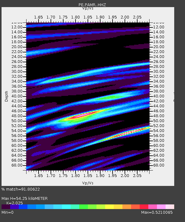
| Estimated Moho Depth: |
54.25 km |
| Estimated Crust Vp/Vs: |
2.03 |
| Assumed Crust Vp: |
6.483 km/s |
| Estimated Crust Vs: |
3.201 km/s |
| Estimated Crust Poisson's Ratio: |
0.34 |
|
| Radial Match: |
91.80622 % |
| Radial Bump: |
231 |
| Transverse Match: |
70.84544 % |
| Transverse Bump: |
400 |
| SOD ConfigId: |
23341671 |
| Insert Time: |
2021-02-27 15:27:17.466 +0000 |
| GWidth: |
2.5 |
| Max Bumps: |
400 |
| Tol: |
0.001 |
|

Signal To Noise
| Channel | StoN | STA | LTA |
| PE:PAMR: :HHZ:20210213T14:20:24.960025Z | 2.3223708 | 1.092724E-6 | 4.7052086E-7 |
| PE:PAMR: :HHN:20210213T14:20:24.960025Z | 1.235458 | 4.61436E-7 | 3.734939E-7 |
| PE:PAMR: :HHE:20210213T14:20:24.960025Z | 1.3858356 | 5.5292986E-7 | 3.989866E-7 |
| Arrivals |
| Ps | 8.7 SECOND |
| PpPs | 25 SECOND |
| PsPs/PpSs | 34 SECOND |


