You are here: Home > Network List > PL - Polish Seismological Network Stations List
> Station SUW PLSN/GEOFON Station Suwalki, Poland > Earthquake Result Viewer
SUW PLSN/GEOFON Station Suwalki, Poland - Earthquake Result Viewer
| Earthquake location: |
Near East Coast Of Honshu, Japan |
| Earthquake latitude/longitude: |
37.7/142.0 |
| Earthquake time(UTC): |
2021/02/13 (044) 14:07:49 GMT |
| Earthquake Depth: |
54 km |
| Earthquake Magnitude: |
7.0 mww |
| Earthquake Catalog/Contributor: |
NEIC PDE/us |
|
| Network: |
PL Polish Seismological Network |
| Station: |
SUW PLSN/GEOFON Station Suwalki, Poland |
| Lat/Lon: |
54.01 N/23.18 E |
| Elevation: |
152 m |
|
| Distance: |
74.6 deg |
| Az: |
327.559 deg |
| Baz: |
46.144 deg |
| Ray Param: |
0.052132703 |
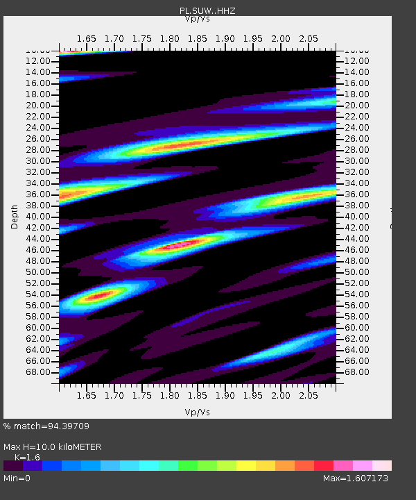
| Estimated Moho Depth: |
10.0 km |
| Estimated Crust Vp/Vs: |
1.60 |
| Assumed Crust Vp: |
6.53 km/s |
| Estimated Crust Vs: |
4.082 km/s |
| Estimated Crust Poisson's Ratio: |
0.18 |
|
| Radial Match: |
94.39709 % |
| Radial Bump: |
400 |
| Transverse Match: |
85.294975 % |
| Transverse Bump: |
400 |
| SOD ConfigId: |
23341671 |
| Insert Time: |
2021-02-27 15:27:35.601 +0000 |
| GWidth: |
2.5 |
| Max Bumps: |
400 |
| Tol: |
0.001 |
|

Signal To Noise
| Channel | StoN | STA | LTA |
| PL:SUW: :HHZ:20210213T14:18:52.018008Z | 10.399185 | 4.3871514E-6 | 4.2187455E-7 |
| PL:SUW: :HHN:20210213T14:18:52.018008Z | 2.772168 | 1.8564342E-6 | 6.6966874E-7 |
| PL:SUW: :HHE:20210213T14:18:52.018008Z | 2.0791051 | 1.3002488E-6 | 6.253887E-7 |
| Arrivals |
| Ps | 1.0 SECOND |
| PpPs | 3.8 SECOND |
| PsPs/PpSs | 4.8 SECOND |


