You are here: Home > Network List > PY - PFO Array Stations List
> Station BPH01 Pinon Flat Observatory, CA, USA > Earthquake Result Viewer
BPH01 Pinon Flat Observatory, CA, USA - Earthquake Result Viewer
| Earthquake location: |
Near East Coast Of Honshu, Japan |
| Earthquake latitude/longitude: |
37.7/142.0 |
| Earthquake time(UTC): |
2021/02/13 (044) 14:07:49 GMT |
| Earthquake Depth: |
54 km |
| Earthquake Magnitude: |
7.0 mww |
| Earthquake Catalog/Contributor: |
NEIC PDE/us |
|
| Network: |
PY PFO Array |
| Station: |
BPH01 Pinon Flat Observatory, CA, USA |
| Lat/Lon: |
33.61 N/116.46 W |
| Elevation: |
1292 m |
|
| Distance: |
78.3 deg |
| Az: |
56.613 deg |
| Baz: |
307.459 deg |
| Ray Param: |
0.049639218 |
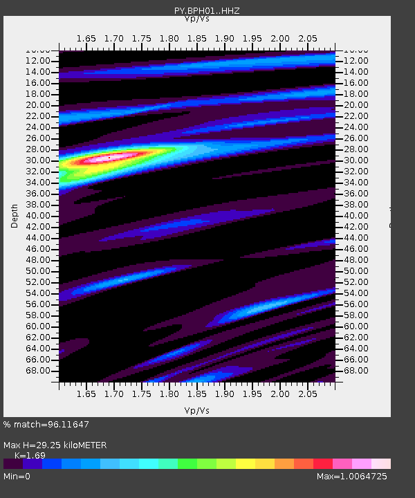
| Estimated Moho Depth: |
29.25 km |
| Estimated Crust Vp/Vs: |
1.69 |
| Assumed Crust Vp: |
6.264 km/s |
| Estimated Crust Vs: |
3.706 km/s |
| Estimated Crust Poisson's Ratio: |
0.23 |
|
| Radial Match: |
96.11647 % |
| Radial Bump: |
253 |
| Transverse Match: |
87.27573 % |
| Transverse Bump: |
400 |
| SOD ConfigId: |
23341671 |
| Insert Time: |
2021-02-27 15:27:56.847 +0000 |
| GWidth: |
2.5 |
| Max Bumps: |
400 |
| Tol: |
0.001 |
|

Signal To Noise
| Channel | StoN | STA | LTA |
| PY:BPH01: :HHZ:20210213T14:19:12.940982Z | 2.562598 | 7.7437267E-7 | 3.0218266E-7 |
| PY:BPH01: :HHN:20210213T14:19:12.940982Z | 1.8643211 | 2.890731E-7 | 1.5505543E-7 |
| PY:BPH01: :HHE:20210213T14:19:12.940982Z | 1.5132731 | 3.0896302E-7 | 2.0416871E-7 |
| Arrivals |
| Ps | 3.3 SECOND |
| PpPs | 12 SECOND |
| PsPs/PpSs | 16 SECOND |


