You are here: Home > Network List > PY - PFO Array Stations List
> Station BPH05 Pinon Flat Observatory, CA, USA > Earthquake Result Viewer
BPH05 Pinon Flat Observatory, CA, USA - Earthquake Result Viewer
| Earthquake location: |
Near East Coast Of Honshu, Japan |
| Earthquake latitude/longitude: |
37.7/142.0 |
| Earthquake time(UTC): |
2021/02/13 (044) 14:07:49 GMT |
| Earthquake Depth: |
54 km |
| Earthquake Magnitude: |
7.0 mww |
| Earthquake Catalog/Contributor: |
NEIC PDE/us |
|
| Network: |
PY PFO Array |
| Station: |
BPH05 Pinon Flat Observatory, CA, USA |
| Lat/Lon: |
33.61 N/116.46 W |
| Elevation: |
1302 m |
|
| Distance: |
78.3 deg |
| Az: |
56.612 deg |
| Baz: |
307.459 deg |
| Ray Param: |
0.04963972 |
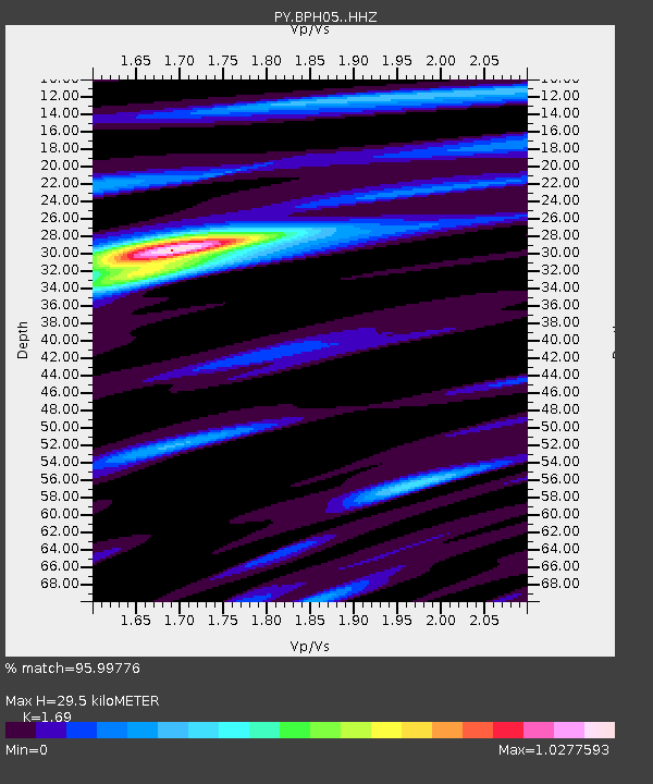
| Estimated Moho Depth: |
29.5 km |
| Estimated Crust Vp/Vs: |
1.69 |
| Assumed Crust Vp: |
6.264 km/s |
| Estimated Crust Vs: |
3.706 km/s |
| Estimated Crust Poisson's Ratio: |
0.23 |
|
| Radial Match: |
95.99776 % |
| Radial Bump: |
272 |
| Transverse Match: |
87.04396 % |
| Transverse Bump: |
400 |
| SOD ConfigId: |
23341671 |
| Insert Time: |
2021-02-27 15:28:02.037 +0000 |
| GWidth: |
2.5 |
| Max Bumps: |
400 |
| Tol: |
0.001 |
|

Signal To Noise
| Channel | StoN | STA | LTA |
| PY:BPH05: :HHZ:20210213T14:19:12.935977Z | 2.5806854 | 7.8600993E-7 | 3.045741E-7 |
| PY:BPH05: :HHN:20210213T14:19:12.935977Z | 1.7651603 | 2.8885992E-7 | 1.6364515E-7 |
| PY:BPH05: :HHE:20210213T14:19:12.935977Z | 1.6104219 | 3.3316508E-7 | 2.0688061E-7 |
| Arrivals |
| Ps | 3.3 SECOND |
| PpPs | 12 SECOND |
| PsPs/PpSs | 16 SECOND |


