You are here: Home > Network List > RV - Regional Alberta Seismic Observatory for Earthquake Studies Network Stations List
> Station EGLEA Eagle Lookout Tower, AB > Earthquake Result Viewer
EGLEA Eagle Lookout Tower, AB - Earthquake Result Viewer
| Earthquake location: |
Near East Coast Of Honshu, Japan |
| Earthquake latitude/longitude: |
37.7/142.0 |
| Earthquake time(UTC): |
2021/02/13 (044) 14:07:49 GMT |
| Earthquake Depth: |
54 km |
| Earthquake Magnitude: |
7.0 mww |
| Earthquake Catalog/Contributor: |
NEIC PDE/us |
|
| Network: |
RV Regional Alberta Seismic Observatory for Earthquake Studies Network |
| Station: |
EGLEA Eagle Lookout Tower, AB |
| Lat/Lon: |
54.46 N/116.44 W |
| Elevation: |
1056 m |
|
| Distance: |
66.3 deg |
| Az: |
38.648 deg |
| Baz: |
301.943 deg |
| Ray Param: |
0.05756617 |
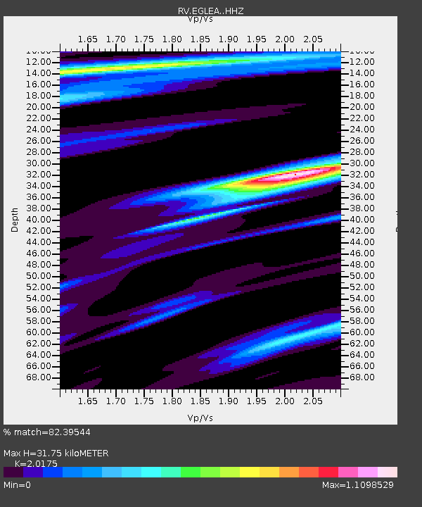
| Estimated Moho Depth: |
31.75 km |
| Estimated Crust Vp/Vs: |
2.02 |
| Assumed Crust Vp: |
6.426 km/s |
| Estimated Crust Vs: |
3.185 km/s |
| Estimated Crust Poisson's Ratio: |
0.34 |
|
| Radial Match: |
82.39544 % |
| Radial Bump: |
350 |
| Transverse Match: |
72.13828 % |
| Transverse Bump: |
400 |
| SOD ConfigId: |
23341671 |
| Insert Time: |
2021-02-27 15:28:31.264 +0000 |
| GWidth: |
2.5 |
| Max Bumps: |
400 |
| Tol: |
0.001 |
|

Signal To Noise
| Channel | StoN | STA | LTA |
| RV:EGLEA: :HHZ:20210213T14:18:01.880008Z | 4.4966545 | 2.5050106E-6 | 5.5708324E-7 |
| RV:EGLEA: :HHN:20210213T14:18:01.880008Z | 0.79574627 | 1.1389219E-6 | 1.4312627E-6 |
| RV:EGLEA: :HHE:20210213T14:18:01.880008Z | 0.5225199 | 7.837152E-7 | 1.4998764E-6 |
| Arrivals |
| Ps | 5.2 SECOND |
| PpPs | 14 SECOND |
| PsPs/PpSs | 20 SECOND |


