You are here: Home > Network List > RV - Regional Alberta Seismic Observatory for Earthquake Studies Network Stations List
> Station REDDA Red Deer Airport, AB > Earthquake Result Viewer
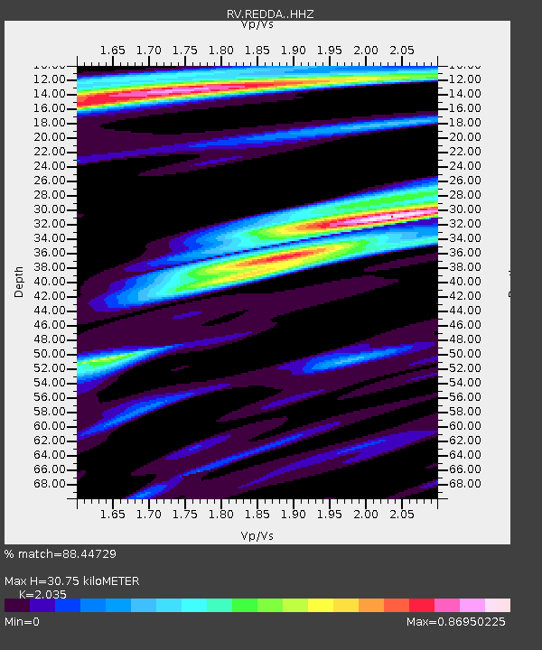
REDDA Red Deer Airport, AB - Earthquake Result Viewer
| Earthquake location: |
Near East Coast Of Honshu, Japan |
| Earthquake latitude/longitude: |
37.7/142.0 |
| Earthquake time(UTC): |
2021/02/13 (044) 14:07:49 GMT |
| Earthquake Depth: |
54 km |
| Earthquake Magnitude: |
7.0 mww |
| Earthquake Catalog/Contributor: |
NEIC PDE/us |
|
| Network: |
RV Regional Alberta Seismic Observatory for Earthquake Studies Network |
| Station: |
REDDA Red Deer Airport, AB |
| Lat/Lon: |
52.18 N/113.90 W |
| Elevation: |
892 m |
|
| Distance: |
68.9 deg |
| Az: |
39.813 deg |
| Baz: |
304.417 deg |
| Ray Param: |
0.055918023 |
| Estimated Moho Depth: |
30.75 km |
| Estimated Crust Vp/Vs: |
2.04 |
| Assumed Crust Vp: |
6.483 km/s |
| Estimated Crust Vs: |
3.186 km/s |
| Estimated Crust Poisson's Ratio: |
0.34 |
|
| Radial Match: |
88.44729 % |
| Radial Bump: |
367 |
| Transverse Match: |
85.36072 % |
| Transverse Bump: |
400 |
| SOD ConfigId: |
23341671 |
| Insert Time: |
2021-02-27 15:28:40.814 +0000 |
| GWidth: |
2.5 |
| Max Bumps: |
400 |
| Tol: |
0.001 |
|

Signal To Noise
| Channel | StoN | STA | LTA |
| RV:REDDA: :HHZ:20210213T14:18:17.739993Z | 2.3352706 | 1.5053351E-6 | 6.446084E-7 |
| RV:REDDA: :HHN:20210213T14:18:17.739993Z | 0.4586887 | 3.913034E-7 | 8.530914E-7 |
| RV:REDDA: :HHE:20210213T14:18:17.739993Z | 1.2015518 | 1.0434375E-6 | 8.684083E-7 |
| Arrivals |
| Ps | 5.1 SECOND |
| PpPs | 14 SECOND |
| PsPs/PpSs | 19 SECOND |


