You are here: Home > Network List > S1 - Australian Seismometers in Schools Stations List
> Station AUPHS Peel High School > Earthquake Result Viewer
AUPHS Peel High School - Earthquake Result Viewer
| Earthquake location: |
Near East Coast Of Honshu, Japan |
| Earthquake latitude/longitude: |
37.7/142.0 |
| Earthquake time(UTC): |
2021/02/13 (044) 14:07:49 GMT |
| Earthquake Depth: |
54 km |
| Earthquake Magnitude: |
7.0 mww |
| Earthquake Catalog/Contributor: |
NEIC PDE/us |
|
| Network: |
S1 Australian Seismometers in Schools |
| Station: |
AUPHS Peel High School |
| Lat/Lon: |
31.10 S/150.89 E |
| Elevation: |
404 m |
|
| Distance: |
68.9 deg |
| Az: |
171.822 deg |
| Baz: |
352.44 deg |
| Ray Param: |
0.055870343 |
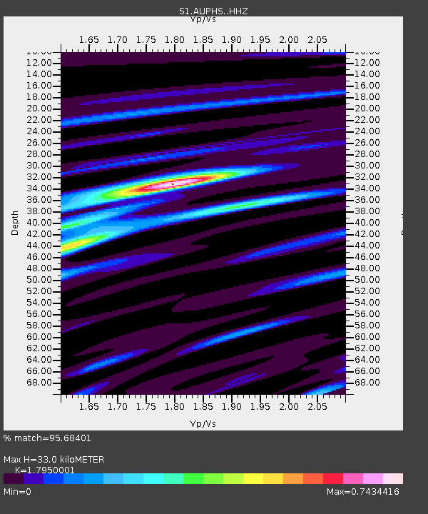
| Estimated Moho Depth: |
33.0 km |
| Estimated Crust Vp/Vs: |
1.80 |
| Assumed Crust Vp: |
6.577 km/s |
| Estimated Crust Vs: |
3.664 km/s |
| Estimated Crust Poisson's Ratio: |
0.27 |
|
| Radial Match: |
95.68401 % |
| Radial Bump: |
235 |
| Transverse Match: |
88.1594 % |
| Transverse Bump: |
400 |
| SOD ConfigId: |
23341671 |
| Insert Time: |
2021-02-27 15:29:17.030 +0000 |
| GWidth: |
2.5 |
| Max Bumps: |
400 |
| Tol: |
0.001 |
|

Signal To Noise
| Channel | StoN | STA | LTA |
| S1:AUPHS: :HHZ:20210213T14:18:18.179996Z | 8.445667 | 2.7037827E-6 | 3.201384E-7 |
| S1:AUPHS: :HHN:20210213T14:18:18.179996Z | 3.7386186 | 1.24979E-6 | 3.342919E-7 |
| S1:AUPHS: :HHE:20210213T14:18:18.179996Z | 0.9671686 | 4.6271342E-7 | 4.7842065E-7 |
| Arrivals |
| Ps | 4.1 SECOND |
| PpPs | 13 SECOND |
| PsPs/PpSs | 18 SECOND |


