You are here: Home > Network List > TA - USArray Transportable Network (new EarthScope stations) Stations List
> Station D23K Nanushuk River, AK USA > Earthquake Result Viewer
D23K Nanushuk River, AK USA - Earthquake Result Viewer
| Earthquake location: |
Near East Coast Of Honshu, Japan |
| Earthquake latitude/longitude: |
37.7/142.0 |
| Earthquake time(UTC): |
2021/02/13 (044) 14:07:49 GMT |
| Earthquake Depth: |
54 km |
| Earthquake Magnitude: |
7.0 mww |
| Earthquake Catalog/Contributor: |
NEIC PDE/us |
|
| Network: |
TA USArray Transportable Network (new EarthScope stations) |
| Station: |
D23K Nanushuk River, AK USA |
| Lat/Lon: |
68.97 N/150.68 W |
| Elevation: |
406 m |
|
| Distance: |
47.3 deg |
| Az: |
26.953 deg |
| Baz: |
264.894 deg |
| Ray Param: |
0.06992802 |
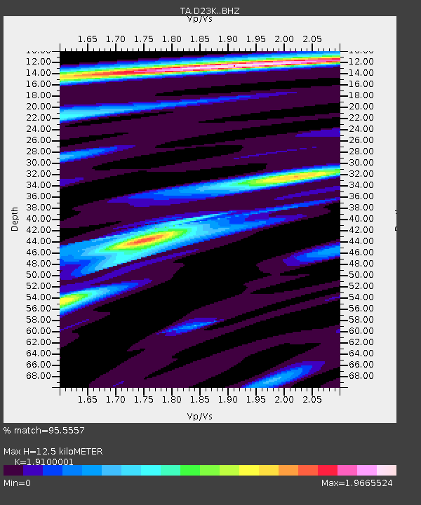
| Estimated Moho Depth: |
12.5 km |
| Estimated Crust Vp/Vs: |
1.91 |
| Assumed Crust Vp: |
6.221 km/s |
| Estimated Crust Vs: |
3.257 km/s |
| Estimated Crust Poisson's Ratio: |
0.31 |
|
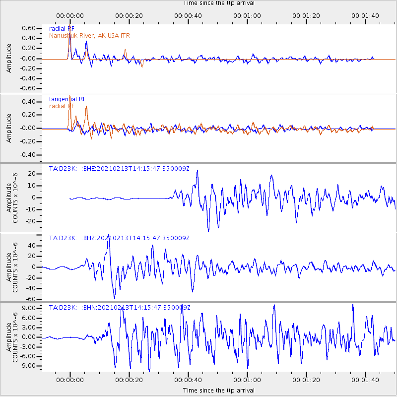
| Radial Match: |
95.5557 % |
| Radial Bump: |
400 |
| Transverse Match: |
90.56177 % |
| Transverse Bump: |
400 |
| SOD ConfigId: |
23341671 |
| Insert Time: |
2021-02-27 15:29:46.158 +0000 |
| GWidth: |
2.5 |
| Max Bumps: |
400 |
| Tol: |
0.001 |
|
Signal To Noise
| Channel | StoN | STA | LTA |
| TA:D23K: :BHZ:20210213T14:15:47.350009Z | 2.418312 | 2.6862501E-6 | 1.1107956E-6 |
| TA:D23K: :BHN:20210213T14:15:47.350009Z | 0.4598317 | 2.0249246E-7 | 4.403621E-7 |
| TA:D23K: :BHE:20210213T14:15:47.350009Z | 0.70708257 | 3.3589623E-7 | 4.7504525E-7 |
| Arrivals |
| Ps | 1.9 SECOND |
| PpPs | 5.5 SECOND |
| PsPs/PpSs | 7.5 SECOND |


