You are here: Home > Network List > TA - USArray Transportable Network (new EarthScope stations) Stations List
> Station P32M Atlin, BC, CAN > Earthquake Result Viewer
P32M Atlin, BC, CAN - Earthquake Result Viewer
| Earthquake location: |
Near East Coast Of Honshu, Japan |
| Earthquake latitude/longitude: |
37.7/142.0 |
| Earthquake time(UTC): |
2021/02/13 (044) 14:07:49 GMT |
| Earthquake Depth: |
54 km |
| Earthquake Magnitude: |
7.0 mww |
| Earthquake Catalog/Contributor: |
NEIC PDE/us |
|
| Network: |
TA USArray Transportable Network (new EarthScope stations) |
| Station: |
P32M Atlin, BC, CAN |
| Lat/Lon: |
59.59 N/133.71 W |
| Elevation: |
793 m |
|
| Distance: |
55.7 deg |
| Az: |
37.815 deg |
| Baz: |
287.027 deg |
| Ray Param: |
0.06453239 |
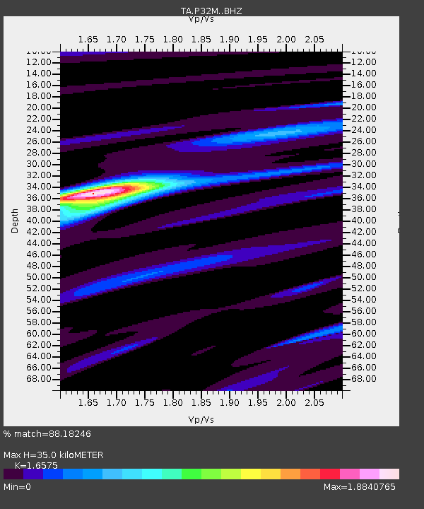
| Estimated Moho Depth: |
35.0 km |
| Estimated Crust Vp/Vs: |
1.66 |
| Assumed Crust Vp: |
6.597 km/s |
| Estimated Crust Vs: |
3.98 km/s |
| Estimated Crust Poisson's Ratio: |
0.21 |
|
| Radial Match: |
88.18246 % |
| Radial Bump: |
400 |
| Transverse Match: |
85.429565 % |
| Transverse Bump: |
383 |
| SOD ConfigId: |
23341671 |
| Insert Time: |
2021-02-27 15:30:32.161 +0000 |
| GWidth: |
2.5 |
| Max Bumps: |
400 |
| Tol: |
0.001 |
|

Signal To Noise
| Channel | StoN | STA | LTA |
| TA:P32M: :BHZ:20210213T14:16:49.599979Z | 0.88805693 | 1.0803991E-6 | 1.2165875E-6 |
| TA:P32M: :BHN:20210213T14:16:49.599979Z | 1.8316958 | 1.1378789E-6 | 6.212161E-7 |
| TA:P32M: :BHE:20210213T14:16:49.599979Z | 2.2637837 | 2.0207071E-6 | 8.926238E-7 |
| Arrivals |
| Ps | 3.7 SECOND |
| PpPs | 13 SECOND |
| PsPs/PpSs | 17 SECOND |


