You are here: Home > Network List > TX - Texas Seismological Network Stations List
> Station PH02 Texas Public Hunt System CROSS BAR MGT AREA > Earthquake Result Viewer
PH02 Texas Public Hunt System CROSS BAR MGT AREA - Earthquake Result Viewer
| Earthquake location: |
Near East Coast Of Honshu, Japan |
| Earthquake latitude/longitude: |
37.7/142.0 |
| Earthquake time(UTC): |
2021/02/13 (044) 14:07:49 GMT |
| Earthquake Depth: |
54 km |
| Earthquake Magnitude: |
7.0 mww |
| Earthquake Catalog/Contributor: |
NEIC PDE/us |
|
| Network: |
TX Texas Seismological Network |
| Station: |
PH02 Texas Public Hunt System CROSS BAR MGT AREA |
| Lat/Lon: |
35.39 N/101.95 W |
| Elevation: |
1022 m |
|
| Distance: |
86.2 deg |
| Az: |
47.357 deg |
| Baz: |
314.417 deg |
| Ray Param: |
0.044128556 |
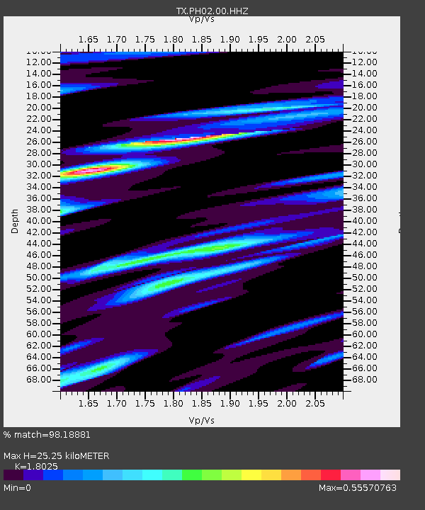
| Estimated Moho Depth: |
25.25 km |
| Estimated Crust Vp/Vs: |
1.80 |
| Assumed Crust Vp: |
6.426 km/s |
| Estimated Crust Vs: |
3.565 km/s |
| Estimated Crust Poisson's Ratio: |
0.28 |
|
| Radial Match: |
98.18881 % |
| Radial Bump: |
259 |
| Transverse Match: |
89.93977 % |
| Transverse Bump: |
400 |
| SOD ConfigId: |
23341671 |
| Insert Time: |
2021-02-27 15:31:33.286 +0000 |
| GWidth: |
2.5 |
| Max Bumps: |
400 |
| Tol: |
0.001 |
|

Signal To Noise
| Channel | StoN | STA | LTA |
| TX:PH02:00:HHZ:20210213T14:19:54.07001Z | 1.8766263 | 8.575897E-7 | 4.5698485E-7 |
| TX:PH02:00:HH1:20210213T14:19:54.07001Z | 0.7117084 | 3.0950676E-7 | 4.348786E-7 |
| TX:PH02:00:HH2:20210213T14:19:54.07001Z | 1.0303596 | 5.480388E-7 | 5.318908E-7 |
| Arrivals |
| Ps | 3.2 SECOND |
| PpPs | 11 SECOND |
| PsPs/PpSs | 14 SECOND |


