You are here: Home > Network List > GE - GEOFON Stations List
> Station KMBO IRIS/GEOFON Station Kilima Mbogo, Kenya > Earthquake Result Viewer
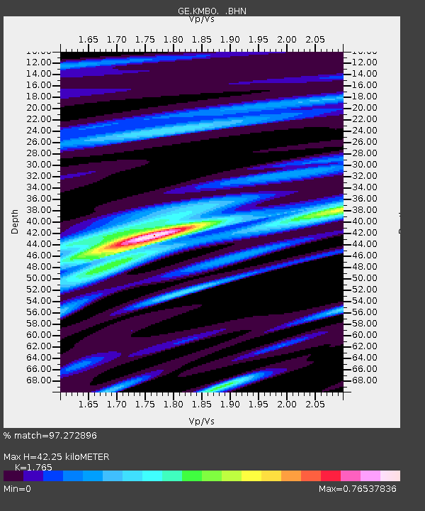
KMBO IRIS/GEOFON Station Kilima Mbogo, Kenya - Earthquake Result Viewer
| Earthquake location: |
Yunnan, China |
| Earthquake latitude/longitude: |
27.3/100.3 |
| Earthquake time(UTC): |
1996/02/03 (034) 11:14:19 GMT |
| Earthquake Depth: |
10 km |
| Earthquake Magnitude: |
6.3 MB, 6.5 MS, 6.6 UNKNOWN, 6.6 ME |
| Earthquake Catalog/Contributor: |
WHDF/NEIC |
|
| Network: |
GE GEOFON |
| Station: |
KMBO IRIS/GEOFON Station Kilima Mbogo, Kenya |
| Lat/Lon: |
1.13 S/37.25 E |
| Elevation: |
1940 m |
|
| Distance: |
66.8 deg |
| Az: |
255.907 deg |
| Baz: |
59.684 deg |
| Ray Param: |
0.05736903 |
| Estimated Moho Depth: |
42.25 km |
| Estimated Crust Vp/Vs: |
1.76 |
| Assumed Crust Vp: |
6.601 km/s |
| Estimated Crust Vs: |
3.74 km/s |
| Estimated Crust Poisson's Ratio: |
0.26 |
|
| Radial Match: |
97.272896 % |
| Radial Bump: |
293 |
| Transverse Match: |
88.699814 % |
| Transverse Bump: |
400 |
| SOD ConfigId: |
6273 |
| Insert Time: |
2010-03-09 05:29:47.846 +0000 |
| GWidth: |
2.5 |
| Max Bumps: |
400 |
| Tol: |
0.001 |
|

Signal To Noise
| Channel | StoN | STA | LTA |
| GE:KMBO: :BHN:19960203T11:24:40.339001Z | 2.0625997 | 1.2969815E-7 | 6.2880915E-8 |
| GE:KMBO: :BHE:19960203T11:24:40.339001Z | 3.5754719 | 1.9047805E-7 | 5.3273542E-8 |
| GE:KMBO: :BHZ:19960203T11:24:40.339001Z | 7.467219 | 4.4567133E-7 | 5.9683714E-8 |
| Arrivals |
| Ps | 5.1 SECOND |
| PpPs | 17 SECOND |
| PsPs/PpSs | 22 SECOND |


