You are here: Home > Network List > US - United States National Seismic Network Stations List
> Station AMTX Amarillo, Texas, USA > Earthquake Result Viewer
AMTX Amarillo, Texas, USA - Earthquake Result Viewer
*The percent match for this event was below the threshold and hence no stack was calculated.
| Earthquake location: |
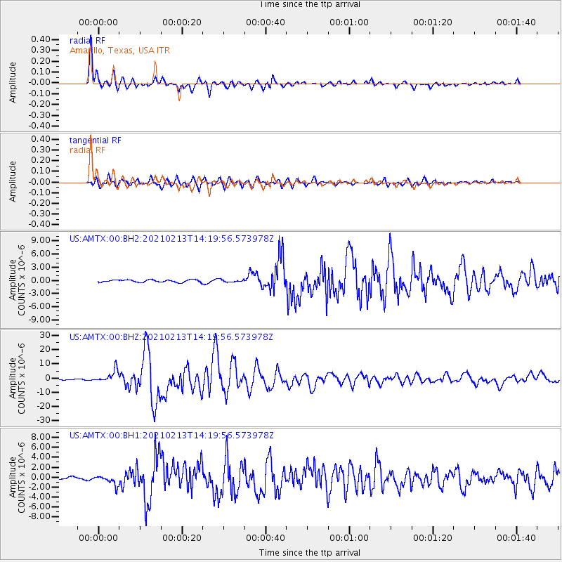
Near East Coast Of Honshu, Japan |
| Earthquake latitude/longitude: |
37.7/142.0 |
| Earthquake time(UTC): |
2021/02/13 (044) 14:07:49 GMT |
| Earthquake Depth: |
54 km |
| Earthquake Magnitude: |
7.0 mww |
| Earthquake Catalog/Contributor: |
NEIC PDE/us |
|
| Network: |
US United States National Seismic Network |
| Station: |
AMTX Amarillo, Texas, USA |
| Lat/Lon: |
34.53 N/101.41 W |
| Elevation: |
1010 m |
|
| Distance: |
87.1 deg |
| Az: |
47.659 deg |
| Baz: |
314.742 deg |
| Ray Param: |
$rayparam |
*The percent match for this event was below the threshold and hence was not used in the summary stack. |
|
| Radial Match: |
97.018105 % |
| Radial Bump: |
287 |
| Transverse Match: |
92.80467 % |
| Transverse Bump: |
400 |
| SOD ConfigId: |
23341671 |
| Insert Time: |
2021-02-27 15:32:18.573 +0000 |
| GWidth: |
2.5 |
| Max Bumps: |
400 |
| Tol: |
0.001 |
|
Signal To Noise
| Channel | StoN | STA | LTA |
| US:AMTX:00:BHZ:20210213T14:19:56.573978Z | 16.680382 | 4.433017E-6 | 2.657623E-7 |
| US:AMTX:00:BH1:20210213T14:19:56.573978Z | 3.0644658 | 1.0320833E-6 | 3.367906E-7 |
| US:AMTX:00:BH2:20210213T14:19:56.573978Z | 3.0779347 | 9.771053E-7 | 3.1745483E-7 |
| Arrivals |
| Ps | |
| PpPs | |
| PsPs/PpSs | |


