You are here: Home > Network List > US - United States National Seismic Network Stations List
> Station EYMN Ely, Minnesota, USA > Earthquake Result Viewer
EYMN Ely, Minnesota, USA - Earthquake Result Viewer
| Earthquake location: |
Near East Coast Of Honshu, Japan |
| Earthquake latitude/longitude: |
37.7/142.0 |
| Earthquake time(UTC): |
2021/02/13 (044) 14:07:49 GMT |
| Earthquake Depth: |
54 km |
| Earthquake Magnitude: |
7.0 mww |
| Earthquake Catalog/Contributor: |
NEIC PDE/us |
|
| Network: |
US United States National Seismic Network |
| Station: |
EYMN Ely, Minnesota, USA |
| Lat/Lon: |
47.95 N/91.50 W |
| Elevation: |
475 m |
|
| Distance: |
82.3 deg |
| Az: |
33.039 deg |
| Baz: |
319.956 deg |
| Ray Param: |
0.046859074 |
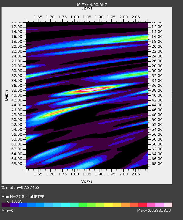
| Estimated Moho Depth: |
37.5 km |
| Estimated Crust Vp/Vs: |
1.87 |
| Assumed Crust Vp: |
6.467 km/s |
| Estimated Crust Vs: |
3.467 km/s |
| Estimated Crust Poisson's Ratio: |
0.30 |
|
| Radial Match: |
97.87453 % |
| Radial Bump: |
389 |
| Transverse Match: |
90.20962 % |
| Transverse Bump: |
400 |
| SOD ConfigId: |
23341671 |
| Insert Time: |
2021-02-27 15:32:30.567 +0000 |
| GWidth: |
2.5 |
| Max Bumps: |
400 |
| Tol: |
0.001 |
|

Signal To Noise
| Channel | StoN | STA | LTA |
| US:EYMN:00:BHZ:20210213T14:19:34.573978Z | 7.5535097 | 4.0956043E-6 | 5.422121E-7 |
| US:EYMN:00:BH1:20210213T14:19:34.573978Z | 5.4392047 | 1.1759772E-6 | 2.1620389E-7 |
| US:EYMN:00:BH2:20210213T14:19:34.573978Z | 2.9295123 | 9.033017E-7 | 3.0834542E-7 |
| Arrivals |
| Ps | 5.1 SECOND |
| PpPs | 16 SECOND |
| PsPs/PpSs | 21 SECOND |


