You are here: Home > Network List > US - United States National Seismic Network Stations List
> Station SCIA State Center, Iowa, USA > Earthquake Result Viewer
SCIA State Center, Iowa, USA - Earthquake Result Viewer

| Earthquake location: |
Near East Coast Of Honshu, Japan |
| Earthquake latitude/longitude: |
37.7/142.0 |
| Earthquake time(UTC): |
2021/02/13 (044) 14:07:49 GMT |
| Earthquake Depth: |
54 km |
| Earthquake Magnitude: |
7.0 mww |
| Earthquake Catalog/Contributor: |
NEIC PDE/us |
|
| Network: |
US United States National Seismic Network |
| Station: |
SCIA State Center, Iowa, USA |
| Lat/Lon: |
41.91 N/93.22 W |
| Elevation: |
312 m |
|
| Distance: |
86.1 deg |
| Az: |
37.908 deg |
| Baz: |
319.232 deg |
| Ray Param: |
0.04416844 |
| Estimated Moho Depth: |
42.0 km |
| Estimated Crust Vp/Vs: |
1.80 |
| Assumed Crust Vp: |
6.498 km/s |
| Estimated Crust Vs: |
3.61 km/s |
| Estimated Crust Poisson's Ratio: |
0.28 |
|
| Radial Match: |
97.429474 % |
| Radial Bump: |
329 |
| Transverse Match: |
92.67533 % |
| Transverse Bump: |
400 |
| SOD ConfigId: |
23341671 |
| Insert Time: |
2021-02-27 15:32:52.651 +0000 |
| GWidth: |
2.5 |
| Max Bumps: |
400 |
| Tol: |
0.001 |
|
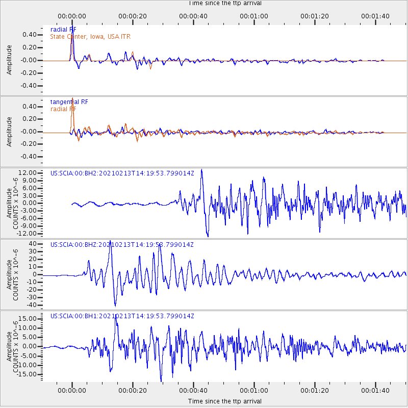
Signal To Noise
| Channel | StoN | STA | LTA |
| US:SCIA:00:BHZ:20210213T14:19:53.799014Z | 1.9088423 | 1.3774314E-6 | 7.2160566E-7 |
| US:SCIA:00:BH1:20210213T14:19:53.799014Z | 1.1859297 | 6.140174E-7 | 5.177519E-7 |
| US:SCIA:00:BH2:20210213T14:19:53.799014Z | 1.4273137 | 6.4426365E-7 | 4.5138196E-7 |
| Arrivals |
| Ps | 5.3 SECOND |
| PpPs | 18 SECOND |
| PsPs/PpSs | 23 SECOND |


