You are here: Home > Network List > UW - Pacific Northwest Regional Seismic Network Stations List
> Station CCRK Sunnyside, WA, USA > Earthquake Result Viewer
CCRK Sunnyside, WA, USA - Earthquake Result Viewer
| Earthquake location: |
Near East Coast Of Honshu, Japan |
| Earthquake latitude/longitude: |
37.7/142.0 |
| Earthquake time(UTC): |
2021/02/13 (044) 14:07:49 GMT |
| Earthquake Depth: |
54 km |
| Earthquake Magnitude: |
7.0 mww |
| Earthquake Catalog/Contributor: |
NEIC PDE/us |
|
| Network: |
UW Pacific Northwest Regional Seismic Network |
| Station: |
CCRK Sunnyside, WA, USA |
| Lat/Lon: |
46.56 N/119.85 W |
| Elevation: |
561 m |
|
| Distance: |
68.7 deg |
| Az: |
47.144 deg |
| Baz: |
302.561 deg |
| Ray Param: |
0.056014393 |
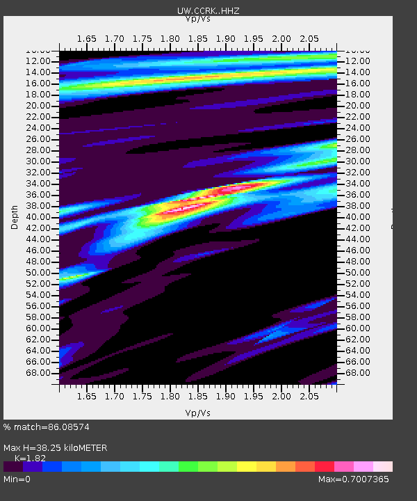
| Estimated Moho Depth: |
38.25 km |
| Estimated Crust Vp/Vs: |
1.82 |
| Assumed Crust Vp: |
6.419 km/s |
| Estimated Crust Vs: |
3.527 km/s |
| Estimated Crust Poisson's Ratio: |
0.28 |
|
| Radial Match: |
86.08574 % |
| Radial Bump: |
324 |
| Transverse Match: |
80.591484 % |
| Transverse Bump: |
400 |
| SOD ConfigId: |
23341671 |
| Insert Time: |
2021-02-27 15:33:26.742 +0000 |
| GWidth: |
2.5 |
| Max Bumps: |
400 |
| Tol: |
0.001 |
|

Signal To Noise
| Channel | StoN | STA | LTA |
| UW:CCRK: :HHZ:20210213T14:18:16.849979Z | 2.1171737 | 1.2071582E-6 | 5.701744E-7 |
| UW:CCRK: :HHN:20210213T14:18:16.849979Z | 1.1390034 | 5.609601E-7 | 4.9250076E-7 |
| UW:CCRK: :HHE:20210213T14:18:16.849979Z | 0.8600656 | 5.240515E-7 | 6.0931575E-7 |
| Arrivals |
| Ps | 5.1 SECOND |
| PpPs | 16 SECOND |
| PsPs/PpSs | 21 SECOND |


