You are here: Home > Network List > UW - Pacific Northwest Regional Seismic Network Stations List
> Station RATT Rattlesnake Lake, King County, WA > Earthquake Result Viewer
RATT Rattlesnake Lake, King County, WA - Earthquake Result Viewer
| Earthquake location: |
Near East Coast Of Honshu, Japan |
| Earthquake latitude/longitude: |
37.7/142.0 |
| Earthquake time(UTC): |
2021/02/13 (044) 14:07:49 GMT |
| Earthquake Depth: |
54 km |
| Earthquake Magnitude: |
7.0 mww |
| Earthquake Catalog/Contributor: |
NEIC PDE/us |
|
| Network: |
UW Pacific Northwest Regional Seismic Network |
| Station: |
RATT Rattlesnake Lake, King County, WA |
| Lat/Lon: |
47.43 N/121.80 W |
| Elevation: |
442 m |
|
| Distance: |
67.1 deg |
| Az: |
47.108 deg |
| Baz: |
301.128 deg |
| Ray Param: |
0.05705475 |
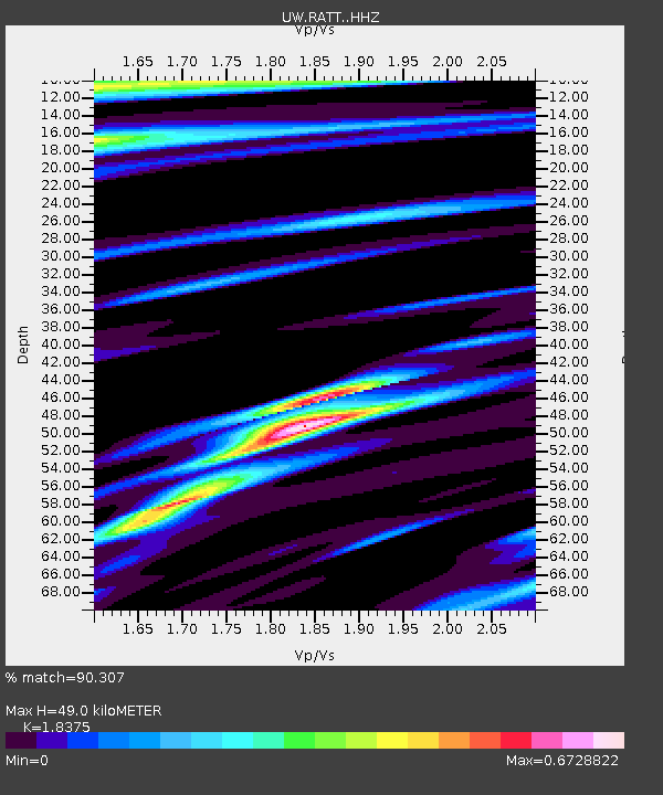
| Estimated Moho Depth: |
49.0 km |
| Estimated Crust Vp/Vs: |
1.84 |
| Assumed Crust Vp: |
6.597 km/s |
| Estimated Crust Vs: |
3.59 km/s |
| Estimated Crust Poisson's Ratio: |
0.29 |
|
| Radial Match: |
90.307 % |
| Radial Bump: |
400 |
| Transverse Match: |
80.27653 % |
| Transverse Bump: |
400 |
| SOD ConfigId: |
23341671 |
| Insert Time: |
2021-02-27 15:33:45.980 +0000 |
| GWidth: |
2.5 |
| Max Bumps: |
400 |
| Tol: |
0.001 |
|

Signal To Noise
| Channel | StoN | STA | LTA |
| UW:RATT: :HHZ:20210213T14:18:06.890018Z | 1.8752484 | 1.2579189E-6 | 6.708012E-7 |
| UW:RATT: :HHN:20210213T14:18:06.890018Z | 0.9615079 | 7.8706597E-7 | 8.185746E-7 |
| UW:RATT: :HHE:20210213T14:18:06.890018Z | 1.4935235 | 1.014561E-6 | 6.7930705E-7 |
| Arrivals |
| Ps | 6.5 SECOND |
| PpPs | 20 SECOND |
| PsPs/PpSs | 27 SECOND |


