You are here: Home > Network List > XL17 - McGill Dawson-Septimus Induced Seismicity Study () Stations List
> Station MG11 Z > Earthquake Result Viewer
MG11 Z - Earthquake Result Viewer
| Earthquake location: |
Near East Coast Of Honshu, Japan |
| Earthquake latitude/longitude: |
37.7/142.0 |
| Earthquake time(UTC): |
2021/02/13 (044) 14:07:49 GMT |
| Earthquake Depth: |
54 km |
| Earthquake Magnitude: |
7.0 mww |
| Earthquake Catalog/Contributor: |
NEIC PDE/us |
|
| Network: |
XL McGill Dawson-Septimus Induced Seismicity Study () |
| Station: |
MG11 Z |
| Lat/Lon: |
55.86 N/120.11 W |
| Elevation: |
657 m |
|
| Distance: |
63.8 deg |
| Az: |
38.487 deg |
| Baz: |
298.865 deg |
| Ray Param: |
0.05921712 |
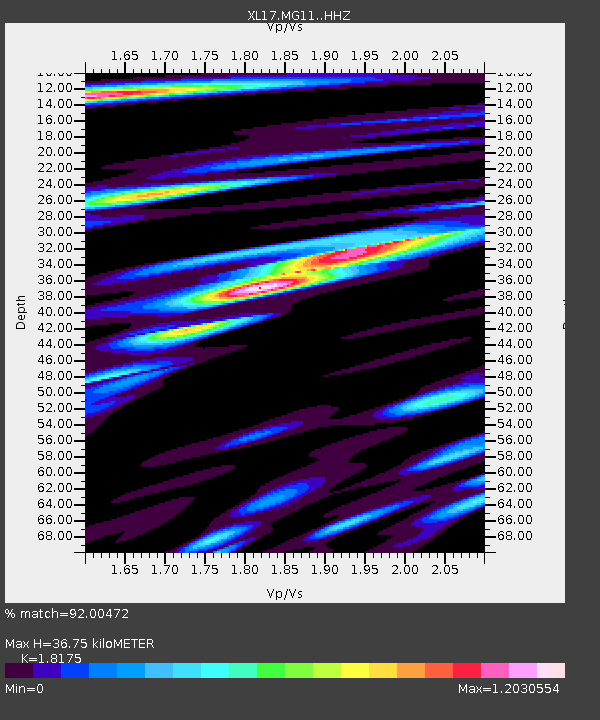
| Estimated Moho Depth: |
36.75 km |
| Estimated Crust Vp/Vs: |
1.82 |
| Assumed Crust Vp: |
6.303 km/s |
| Estimated Crust Vs: |
3.468 km/s |
| Estimated Crust Poisson's Ratio: |
0.28 |
|
| Radial Match: |
92.00472 % |
| Radial Bump: |
400 |
| Transverse Match: |
77.66758 % |
| Transverse Bump: |
400 |
| SOD ConfigId: |
23341671 |
| Insert Time: |
2021-02-27 15:34:54.212 +0000 |
| GWidth: |
2.5 |
| Max Bumps: |
400 |
| Tol: |
0.001 |
|

Signal To Noise
| Channel | StoN | STA | LTA |
| XL:MG11: :HHZ:20210213T14:17:45.510013Z | 3.0472791 | 2.0784898E-6 | 6.8208055E-7 |
| XL:MG11: :HHN:20210213T14:17:45.510013Z | 1.1575767 | 1.250772E-6 | 1.0805089E-6 |
| XL:MG11: :HHE:20210213T14:17:45.510013Z | 1.7526599 | 1.399883E-6 | 7.987191E-7 |
| Arrivals |
| Ps | 5.0 SECOND |
| PpPs | 16 SECOND |
| PsPs/PpSs | 21 SECOND |


