You are here: Home > Network List > YN10 - San Jacinto Fault Zone Stations List
> Station JORD JORD > Earthquake Result Viewer
JORD JORD - Earthquake Result Viewer
| Earthquake location: |
Near East Coast Of Honshu, Japan |
| Earthquake latitude/longitude: |
37.7/142.0 |
| Earthquake time(UTC): |
2021/02/13 (044) 14:07:49 GMT |
| Earthquake Depth: |
54 km |
| Earthquake Magnitude: |
7.0 mww |
| Earthquake Catalog/Contributor: |
NEIC PDE/us |
|
| Network: |
YN San Jacinto Fault Zone |
| Station: |
JORD JORD |
| Lat/Lon: |
33.47 N/116.64 W |
| Elevation: |
1235 m |
|
| Distance: |
78.3 deg |
| Az: |
56.823 deg |
| Baz: |
307.398 deg |
| Ray Param: |
0.04966838 |
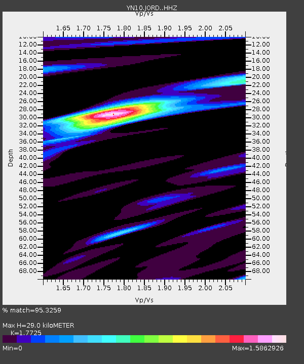
| Estimated Moho Depth: |
29.0 km |
| Estimated Crust Vp/Vs: |
1.77 |
| Assumed Crust Vp: |
6.264 km/s |
| Estimated Crust Vs: |
3.534 km/s |
| Estimated Crust Poisson's Ratio: |
0.27 |
|
| Radial Match: |
95.3259 % |
| Radial Bump: |
395 |
| Transverse Match: |
87.374565 % |
| Transverse Bump: |
400 |
| SOD ConfigId: |
23341671 |
| Insert Time: |
2021-02-27 15:35:02.870 +0000 |
| GWidth: |
2.5 |
| Max Bumps: |
400 |
| Tol: |
0.001 |
|

Signal To Noise
| Channel | StoN | STA | LTA |
| YN:JORD: :HHZ:20210213T14:19:12.713992Z | 2.0102124 | 6.6414816E-7 | 3.3038705E-7 |
| YN:JORD: :HHN:20210213T14:19:12.713992Z | 1.4903609 | 4.2031405E-7 | 2.820217E-7 |
| YN:JORD: :HHE:20210213T14:19:12.713992Z | 0.93926865 | 4.052036E-7 | 4.3140332E-7 |
| Arrivals |
| Ps | 3.7 SECOND |
| PpPs | 12 SECOND |
| PsPs/PpSs | 16 SECOND |


