You are here: Home > Network List > AZ - ANZA Regional Network Stations List
> Station SMER AZ.SMER > Earthquake Result Viewer
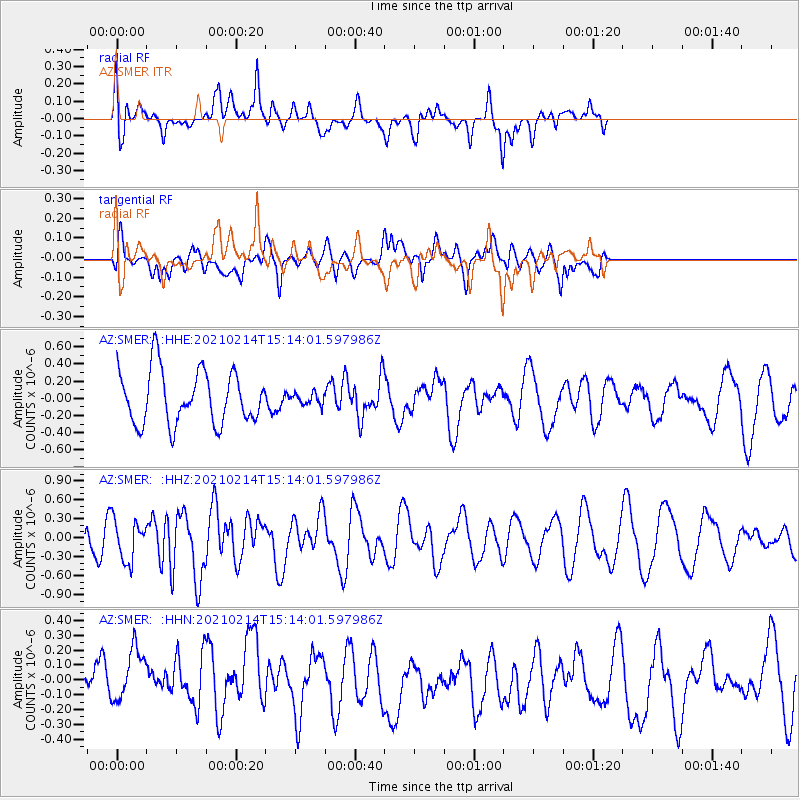
SMER AZ.SMER - Earthquake Result Viewer
*The percent match for this event was below the threshold and hence no stack was calculated.
| Earthquake location: |
Southeast Of Loyalty Islands |
| Earthquake latitude/longitude: |
-23.3/171.7 |
| Earthquake time(UTC): |
2021/02/14 (045) 15:01:42 GMT |
| Earthquake Depth: |
10 km |
| Earthquake Magnitude: |
5.8 mww |
| Earthquake Catalog/Contributor: |
NEIC PDE/us |
|
| Network: |
AZ ANZA Regional Network |
| Station: |
SMER AZ.SMER |
| Lat/Lon: |
33.46 N/117.17 W |
| Elevation: |
355 m |
|
| Distance: |
88.1 deg |
| Az: |
52.312 deg |
| Baz: |
240.525 deg |
| Ray Param: |
$rayparam |
*The percent match for this event was below the threshold and hence was not used in the summary stack. |
|
| Radial Match: |
71.25516 % |
| Radial Bump: |
400 |
| Transverse Match: |
58.559586 % |
| Transverse Bump: |
400 |
| SOD ConfigId: |
23341671 |
| Insert Time: |
2021-02-28 16:05:39.071 +0000 |
| GWidth: |
2.5 |
| Max Bumps: |
400 |
| Tol: |
0.001 |
|
Signal To Noise
| Channel | StoN | STA | LTA |
| AZ:SMER: :HHZ:20210214T15:14:01.597986Z | 1.6466002 | 3.214007E-7 | 1.951905E-7 |
| AZ:SMER: :HHN:20210214T15:14:01.597986Z | 1.5876249 | 2.1713453E-7 | 1.367669E-7 |
| AZ:SMER: :HHE:20210214T15:14:01.597986Z | 0.20959274 | 6.498096E-8 | 3.100344E-7 |
| Arrivals |
| Ps | |
| PpPs | |
| PsPs/PpSs | |


