You are here: Home > Network List > GE - GEOFON Stations List
> Station KMBO IRIS/GEOFON Station Kilima Mbogo, Kenya > Earthquake Result Viewer
KMBO IRIS/GEOFON Station Kilima Mbogo, Kenya - Earthquake Result Viewer
| Earthquake location: |
Banda Sea |
| Earthquake latitude/longitude: |
-7.3/128.5 |
| Earthquake time(UTC): |
2000/03/03 (063) 22:09:13 GMT |
| Earthquake Depth: |
142 km |
| Earthquake Magnitude: |
6.4 MB, 5.8 MS, 6.3 MW, 6.3 MW |
| Earthquake Catalog/Contributor: |
WHDF/NEIC |
|
| Network: |
GE GEOFON |
| Station: |
KMBO IRIS/GEOFON Station Kilima Mbogo, Kenya |
| Lat/Lon: |
1.13 S/37.25 E |
| Elevation: |
1940 m |
|
| Distance: |
91.1 deg |
| Az: |
268.733 deg |
| Baz: |
97.297 deg |
| Ray Param: |
0.041597657 |
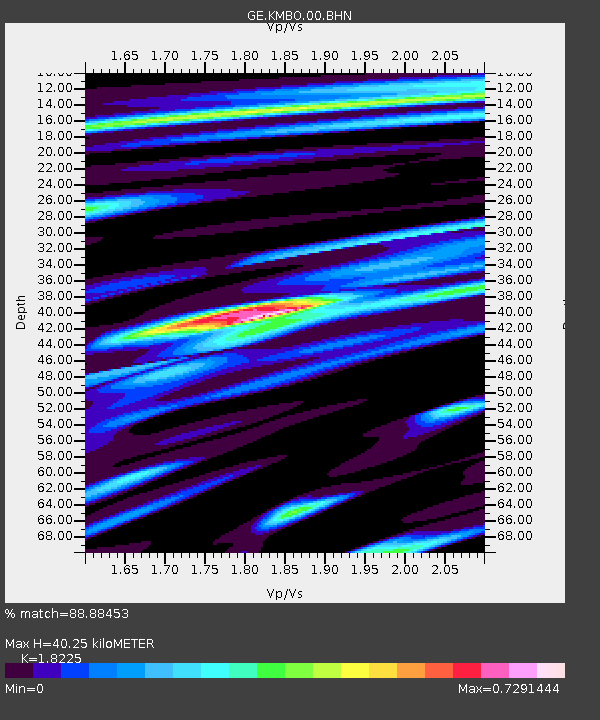
| Estimated Moho Depth: |
40.25 km |
| Estimated Crust Vp/Vs: |
1.82 |
| Assumed Crust Vp: |
6.601 km/s |
| Estimated Crust Vs: |
3.622 km/s |
| Estimated Crust Poisson's Ratio: |
0.28 |
|
| Radial Match: |
88.88453 % |
| Radial Bump: |
400 |
| Transverse Match: |
71.20494 % |
| Transverse Bump: |
400 |
| SOD ConfigId: |
20082 |
| Insert Time: |
2010-03-09 05:30:51.567 +0000 |
| GWidth: |
2.5 |
| Max Bumps: |
400 |
| Tol: |
0.001 |
|

Signal To Noise
| Channel | StoN | STA | LTA |
| GE:KMBO:00:BHN:20000303T22:21:31.008018Z | 1.109017 | 7.372748E-8 | 6.648002E-8 |
| GE:KMBO:00:BHE:20000303T22:21:31.008018Z | 1.6536565 | 1.1747633E-7 | 7.104035E-8 |
| GE:KMBO:00:BHZ:20000303T22:21:31.008018Z | 1.5470655 | 1.44085E-7 | 9.3134396E-8 |
| Arrivals |
| Ps | 5.1 SECOND |
| PpPs | 17 SECOND |
| PsPs/PpSs | 22 SECOND |


