You are here: Home > Network List > GE - GEOFON Stations List
> Station KMBO IRIS/GEOFON Station Kilima Mbogo, Kenya > Earthquake Result Viewer
KMBO IRIS/GEOFON Station Kilima Mbogo, Kenya - Earthquake Result Viewer
| Earthquake location: |
Sulawesi, Indonesia |
| Earthquake latitude/longitude: |
-3.8/119.7 |
| Earthquake time(UTC): |
1997/09/28 (271) 01:38:28 GMT |
| Earthquake Depth: |
33 km |
| Earthquake Magnitude: |
5.6 MB, 5.5 MS, 5.9 UNKNOWN, 5.9 MW |
| Earthquake Catalog/Contributor: |
WHDF/NEIC |
|
| Network: |
GE GEOFON |
| Station: |
KMBO IRIS/GEOFON Station Kilima Mbogo, Kenya |
| Lat/Lon: |
1.13 S/37.25 E |
| Elevation: |
1940 m |
|
| Distance: |
82.4 deg |
| Az: |
269.368 deg |
| Baz: |
93.635 deg |
| Ray Param: |
0.046856955 |
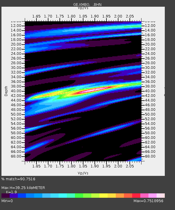
| Estimated Moho Depth: |
39.25 km |
| Estimated Crust Vp/Vs: |
1.90 |
| Assumed Crust Vp: |
6.601 km/s |
| Estimated Crust Vs: |
3.474 km/s |
| Estimated Crust Poisson's Ratio: |
0.31 |
|
| Radial Match: |
90.7516 % |
| Radial Bump: |
342 |
| Transverse Match: |
73.74252 % |
| Transverse Bump: |
400 |
| SOD ConfigId: |
4480 |
| Insert Time: |
2010-03-09 05:31:00.848 +0000 |
| GWidth: |
2.5 |
| Max Bumps: |
400 |
| Tol: |
0.001 |
|

Signal To Noise
| Channel | StoN | STA | LTA |
| GE:KMBO: :BHN:19970928T01:50:16.326013Z | 2.0007067 | 1.6358021E-7 | 8.176121E-8 |
| GE:KMBO: :BHE:19970928T01:50:16.326013Z | 1.3797009 | 9.7478285E-8 | 7.065175E-8 |
| GE:KMBO: :BHZ:19970928T01:50:16.326013Z | 1.1296741 | 5.851065E-8 | 5.1794274E-8 |
| Arrivals |
| Ps | 5.5 SECOND |
| PpPs | 17 SECOND |
| PsPs/PpSs | 22 SECOND |


