You are here: Home > Network List > GE - GEOFON Stations List
> Station KMBO IRIS/GEOFON Station Kilima Mbogo, Kenya > Earthquake Result Viewer
KMBO IRIS/GEOFON Station Kilima Mbogo, Kenya - Earthquake Result Viewer
| Earthquake location: |
South Indian Ocean |
| Earthquake latitude/longitude: |
-13.2/97.3 |
| Earthquake time(UTC): |
2001/09/07 (250) 02:45:59 GMT |
| Earthquake Depth: |
10 km |
| Earthquake Magnitude: |
6.2 MB, 5.8 MS, 6.0 MW, 5.9 MW |
| Earthquake Catalog/Contributor: |
WHDF/NEIC |
|
| Network: |
GE GEOFON |
| Station: |
KMBO IRIS/GEOFON Station Kilima Mbogo, Kenya |
| Lat/Lon: |
1.13 S/37.25 E |
| Elevation: |
1940 m |
|
| Distance: |
60.6 deg |
| Az: |
276.191 deg |
| Baz: |
104.406 deg |
| Ray Param: |
0.061416294 |
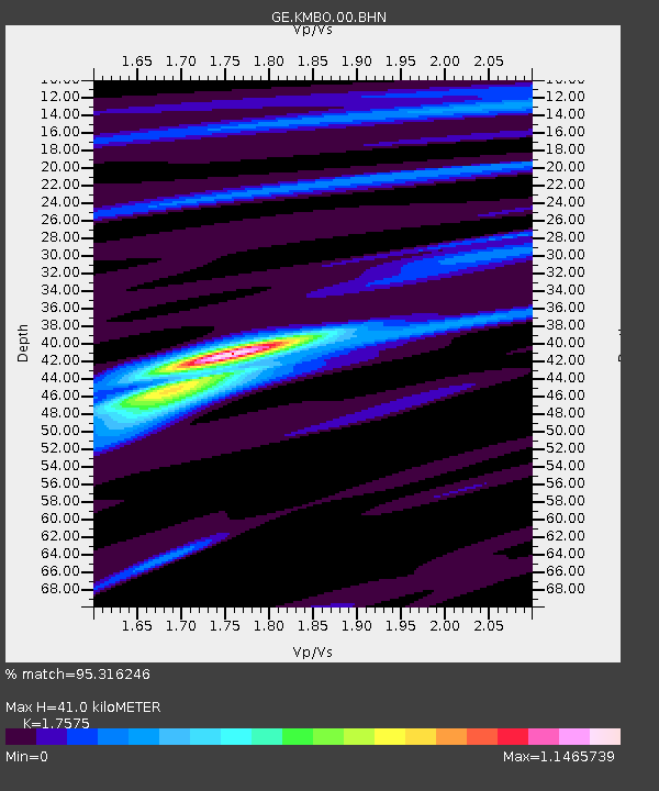
| Estimated Moho Depth: |
41.0 km |
| Estimated Crust Vp/Vs: |
1.76 |
| Assumed Crust Vp: |
6.601 km/s |
| Estimated Crust Vs: |
3.756 km/s |
| Estimated Crust Poisson's Ratio: |
0.26 |
|
| Radial Match: |
95.316246 % |
| Radial Bump: |
224 |
| Transverse Match: |
87.28662 % |
| Transverse Bump: |
389 |
| SOD ConfigId: |
20082 |
| Insert Time: |
2010-03-09 05:31:05.219 +0000 |
| GWidth: |
2.5 |
| Max Bumps: |
400 |
| Tol: |
0.001 |
|

Signal To Noise
| Channel | StoN | STA | LTA |
| GE:KMBO:00:BHN:20010907T02:55:38.77301Z | 0.5337372 | 3.8227757E-8 | 7.1622814E-8 |
| GE:KMBO:00:BHE:20010907T02:55:38.77301Z | 3.4391077 | 3.2461597E-7 | 9.4389584E-8 |
| GE:KMBO:00:BHZ:20010907T02:55:38.77301Z | 12.088356 | 7.4787977E-7 | 6.186778E-8 |
| Arrivals |
| Ps | 4.9 SECOND |
| PpPs | 16 SECOND |
| PsPs/PpSs | 21 SECOND |


