You are here: Home > Network List > GE - GEOFON Stations List
> Station KMBO IRIS/GEOFON Station Kilima Mbogo, Kenya > Earthquake Result Viewer
KMBO IRIS/GEOFON Station Kilima Mbogo, Kenya - Earthquake Result Viewer
| Earthquake location: |
Java, Indonesia |
| Earthquake latitude/longitude: |
-7.9/110.2 |
| Earthquake time(UTC): |
2001/05/25 (145) 05:06:10 GMT |
| Earthquake Depth: |
143 km |
| Earthquake Magnitude: |
5.8 MB, 6.3 MW, 6.3 MW |
| Earthquake Catalog/Contributor: |
WHDF/NEIC |
|
| Network: |
GE GEOFON |
| Station: |
KMBO IRIS/GEOFON Station Kilima Mbogo, Kenya |
| Lat/Lon: |
1.13 S/37.25 E |
| Elevation: |
1940 m |
|
| Distance: |
72.9 deg |
| Az: |
271.233 deg |
| Baz: |
97.834 deg |
| Ray Param: |
0.052971642 |
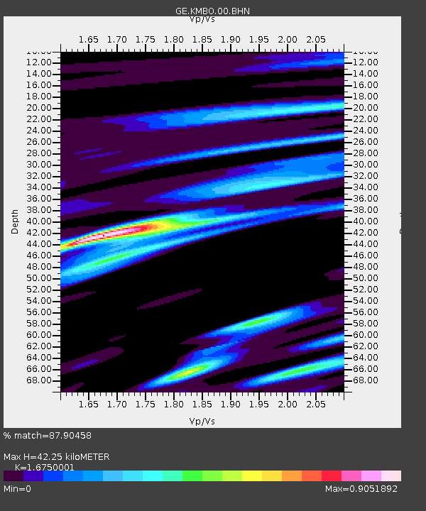
| Estimated Moho Depth: |
42.25 km |
| Estimated Crust Vp/Vs: |
1.68 |
| Assumed Crust Vp: |
6.601 km/s |
| Estimated Crust Vs: |
3.941 km/s |
| Estimated Crust Poisson's Ratio: |
0.22 |
|
| Radial Match: |
87.90458 % |
| Radial Bump: |
382 |
| Transverse Match: |
71.85062 % |
| Transverse Bump: |
400 |
| SOD ConfigId: |
20082 |
| Insert Time: |
2010-03-09 05:31:06.482 +0000 |
| GWidth: |
2.5 |
| Max Bumps: |
400 |
| Tol: |
0.001 |
|

Signal To Noise
| Channel | StoN | STA | LTA |
| GE:KMBO:00:BHN:20010525T05:16:53.411018Z | 0.9295476 | 7.6974125E-8 | 8.280816E-8 |
| GE:KMBO:00:BHE:20010525T05:16:53.411018Z | 1.5175213 | 1.0762698E-7 | 7.092288E-8 |
| GE:KMBO:00:BHZ:20010525T05:16:53.411018Z | 2.272805 | 2.0808824E-7 | 9.15557E-8 |
| Arrivals |
| Ps | 4.5 SECOND |
| PpPs | 16 SECOND |
| PsPs/PpSs | 21 SECOND |


