You are here: Home > Network List > TA - USArray Transportable Network (new EarthScope stations) Stations List
> Station H31M Peel River, Yukon, CAN > Earthquake Result Viewer
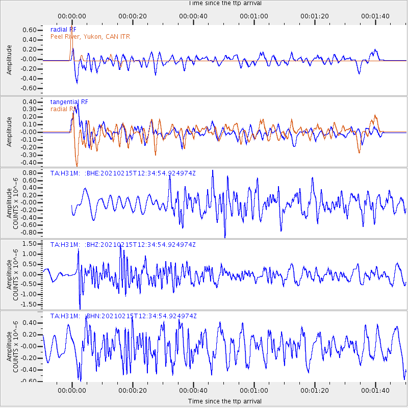
H31M Peel River, Yukon, CAN - Earthquake Result Viewer
*The percent match for this event was below the threshold and hence no stack was calculated.
| Earthquake location: |
Near East Coast Of Honshu, Japan |
| Earthquake latitude/longitude: |
37.5/141.6 |
| Earthquake time(UTC): |
2021/02/15 (046) 12:26:04 GMT |
| Earthquake Depth: |
36 km |
| Earthquake Magnitude: |
5.3 Mww |
| Earthquake Catalog/Contributor: |
NEIC PDE/us |
|
| Network: |
TA USArray Transportable Network (new EarthScope stations) |
| Station: |
H31M Peel River, Yukon, CAN |
| Lat/Lon: |
65.81 N/134.34 W |
| Elevation: |
642 m |
|
| Distance: |
54.1 deg |
| Az: |
30.402 deg |
| Baz: |
282.489 deg |
| Ray Param: |
$rayparam |
*The percent match for this event was below the threshold and hence was not used in the summary stack. |
|
| Radial Match: |
66.16313 % |
| Radial Bump: |
400 |
| Transverse Match: |
71.10303 % |
| Transverse Bump: |
400 |
| SOD ConfigId: |
23341671 |
| Insert Time: |
2021-03-01 13:45:15.049 +0000 |
| GWidth: |
2.5 |
| Max Bumps: |
400 |
| Tol: |
0.001 |
|
Signal To Noise
| Channel | StoN | STA | LTA |
| TA:H31M: :BHZ:20210215T12:34:54.924974Z | 3.9481215 | 5.7006963E-7 | 1.4439009E-7 |
| TA:H31M: :BHN:20210215T12:34:54.924974Z | 1.8503487 | 3.073964E-7 | 1.661289E-7 |
| TA:H31M: :BHE:20210215T12:34:54.924974Z | 1.3603985 | 2.576483E-7 | 1.8939178E-7 |
| Arrivals |
| Ps | |
| PpPs | |
| PsPs/PpSs | |


