You are here: Home > Network List > GE - GEOFON Stations List
> Station KMBO IRIS/GEOFON Station Kilima Mbogo, Kenya > Earthquake Result Viewer
KMBO IRIS/GEOFON Station Kilima Mbogo, Kenya - Earthquake Result Viewer
| Earthquake location: |
Mindanao, Philippines |
| Earthquake latitude/longitude: |
6.0/124.2 |
| Earthquake time(UTC): |
2002/03/05 (064) 21:16:09 GMT |
| Earthquake Depth: |
31 km |
| Earthquake Magnitude: |
6.3 MB, 7.2 MS, 7.5 MW, 7.2 MW |
| Earthquake Catalog/Contributor: |
WHDF/NEIC |
|
| Network: |
GE GEOFON |
| Station: |
KMBO IRIS/GEOFON Station Kilima Mbogo, Kenya |
| Lat/Lon: |
1.13 S/37.25 E |
| Elevation: |
1940 m |
|
| Distance: |
87.1 deg |
| Az: |
268.572 deg |
| Baz: |
83.942 deg |
| Ray Param: |
0.04350667 |
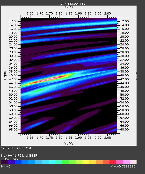
| Estimated Moho Depth: |
41.75 km |
| Estimated Crust Vp/Vs: |
1.75 |
| Assumed Crust Vp: |
6.601 km/s |
| Estimated Crust Vs: |
3.783 km/s |
| Estimated Crust Poisson's Ratio: |
0.26 |
|
| Radial Match: |
97.80434 % |
| Radial Bump: |
325 |
| Transverse Match: |
91.20583 % |
| Transverse Bump: |
400 |
| SOD ConfigId: |
20082 |
| Insert Time: |
2010-03-09 05:31:13.287 +0000 |
| GWidth: |
2.5 |
| Max Bumps: |
400 |
| Tol: |
0.001 |
|

Signal To Noise
| Channel | StoN | STA | LTA |
| GE:KMBO:00:BHN:20020305T21:28:20.695002Z | 1.3661045 | 7.673654E-8 | 5.6171796E-8 |
| GE:KMBO:00:BHE:20020305T21:28:20.695002Z | 3.2495737 | 1.4640946E-7 | 4.5054975E-8 |
| GE:KMBO:00:BHZ:20020305T21:28:20.695002Z | 7.4530706 | 3.7487754E-7 | 5.0298404E-8 |
| Arrivals |
| Ps | 4.8 SECOND |
| PpPs | 17 SECOND |
| PsPs/PpSs | 22 SECOND |


