You are here: Home > Network List > GE - GEOFON Stations List
> Station KMBO IRIS/GEOFON Station Kilima Mbogo, Kenya > Earthquake Result Viewer
KMBO IRIS/GEOFON Station Kilima Mbogo, Kenya - Earthquake Result Viewer
| Earthquake location: |
Taiwan |
| Earthquake latitude/longitude: |
23.5/121.6 |
| Earthquake time(UTC): |
2003/06/10 (161) 08:40:30 GMT |
| Earthquake Depth: |
44 km |
| Earthquake Magnitude: |
5.8 MB, 5.7 MS, 6.0 MW, 5.9 MW |
| Earthquake Catalog/Contributor: |
WHDF/NEIC |
|
| Network: |
GE GEOFON |
| Station: |
KMBO IRIS/GEOFON Station Kilima Mbogo, Kenya |
| Lat/Lon: |
1.13 S/37.25 E |
| Elevation: |
1940 m |
|
| Distance: |
85.3 deg |
| Az: |
266.732 deg |
| Baz: |
66.431 deg |
| Ray Param: |
0.04480251 |
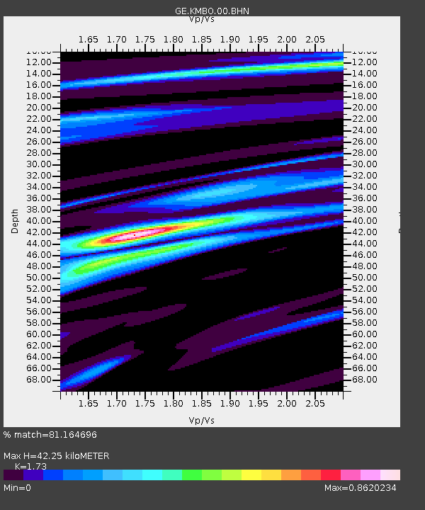
| Estimated Moho Depth: |
42.25 km |
| Estimated Crust Vp/Vs: |
1.73 |
| Assumed Crust Vp: |
6.601 km/s |
| Estimated Crust Vs: |
3.815 km/s |
| Estimated Crust Poisson's Ratio: |
0.25 |
|
| Radial Match: |
81.164696 % |
| Radial Bump: |
400 |
| Transverse Match: |
65.00878 % |
| Transverse Bump: |
400 |
| SOD ConfigId: |
4714 |
| Insert Time: |
2010-03-09 05:31:18.517 +0000 |
| GWidth: |
2.5 |
| Max Bumps: |
400 |
| Tol: |
0.001 |
|

Signal To Noise
| Channel | StoN | STA | LTA |
| GE:KMBO:00:BHN:20030610T08:52:31.798018Z | 1.1533052 | 9.652554E-8 | 8.369471E-8 |
| GE:KMBO:00:BHE:20030610T08:52:31.798018Z | 1.6255909 | 9.432516E-8 | 5.802515E-8 |
| GE:KMBO:00:BHZ:20030610T08:52:31.798018Z | 0.83438444 | 6.9892245E-8 | 8.376504E-8 |
| Arrivals |
| Ps | 4.8 SECOND |
| PpPs | 17 SECOND |
| PsPs/PpSs | 22 SECOND |


