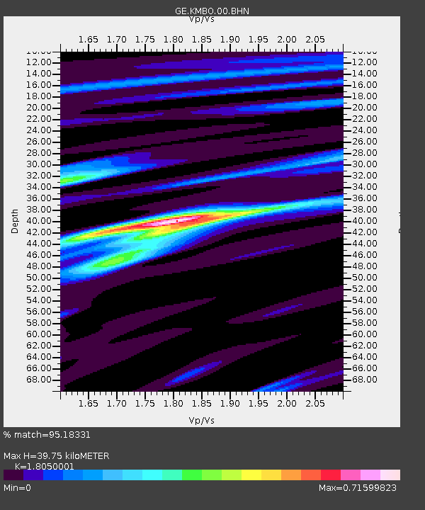
KMBO IRIS/GEOFON Station Kilima Mbogo, Kenya - Earthquake Result Viewer

Earthquake location: Irian Jaya Region, Indonesia
Earthquake latitude/longitude: -4.0/135.0
Earthquake time(UTC): 2004/02/07 (038) 02:42:35 GMT
Earthquake Depth: 10 km
Earthquake Magnitude: 6.2 MB, 7.5 MS, 7.3 MW, 7.3 MW
Earthquake Catalog/Contributor: WHDF/NEIC
Network: GE GEOFON
Station: KMBO IRIS/GEOFON Station Kilima Mbogo, Kenya
Lat/Lon: 1.13 S/37.25 E
Elevation: 1940 m
Distance: 97.7 deg
Az: 268.331 deg
Baz: 94.164 deg
Ray Param: 0.040143646
Estimated Moho Depth: 39.75 km
Estimated Crust Vp/Vs: 1.81
Assumed Crust Vp: 6.601 km/s
Estimated Crust Vs: 3.657 km/s
Estimated Crust Poisson's Ratio: 0.28
Radial Match: 95.18331 %
Radial Bump: 268
Transverse Match: 86.393745 %
Transverse Bump: 400
SOD ConfigId: 2459
Insert Time: 2010-03-09 05:31:36.757 +0000
GWidth: 2.5
Max Bumps: 400
Tol: 0.001

Signal To Noise

ChannelStoNSTALTA
GE:KMBO:00:BHN:20040207T02:55:38.248025Z1.33038441.2697556E-79.544276E-8
GE:KMBO:00:BHE:20040207T02:55:38.248025Z1.41907581.5300398E-71.0781946E-7
GE:KMBO:00:BHZ:20040207T02:55:38.248025Z2.8587764.631825E-71.6202127E-7
Arrivals
Ps4.9 SECOND
PpPs17 SECOND
PsPs/PpSs22 SECOND