You are here: Home > Network List > IU - Global Seismograph Network (GSN - IRIS/USGS) Stations List
> Station RSSD Black Hills, South Dakota, USA > Earthquake Result Viewer
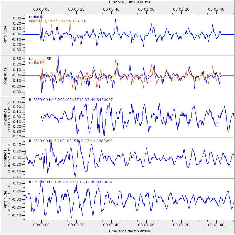
RSSD Black Hills, South Dakota, USA - Earthquake Result Viewer
*The percent match for this event was below the threshold and hence no stack was calculated.
| Earthquake location: |
Near East Coast Of Honshu, Japan |
| Earthquake latitude/longitude: |
37.5/141.4 |
| Earthquake time(UTC): |
2021/02/15 (046) 12:26:18 GMT |
| Earthquake Depth: |
40 km |
| Earthquake Magnitude: |
5.3 Mww |
| Earthquake Catalog/Contributor: |
NEIC PDE/us |
|
| Network: |
IU Global Seismograph Network (GSN - IRIS/USGS) |
| Station: |
RSSD Black Hills, South Dakota, USA |
| Lat/Lon: |
44.12 N/104.04 W |
| Elevation: |
2090 m |
|
| Distance: |
79.5 deg |
| Az: |
41.774 deg |
| Baz: |
312.665 deg |
| Ray Param: |
$rayparam |
*The percent match for this event was below the threshold and hence was not used in the summary stack. |
|
| Radial Match: |
59.935448 % |
| Radial Bump: |
400 |
| Transverse Match: |
67.34784 % |
| Transverse Bump: |
400 |
| SOD ConfigId: |
23341671 |
| Insert Time: |
2021-03-01 13:59:10.404 +0000 |
| GWidth: |
2.5 |
| Max Bumps: |
400 |
| Tol: |
0.001 |
|
Signal To Noise
| Channel | StoN | STA | LTA |
| IU:RSSD:00:HHZ:20210215T12:37:49.848009Z | 1.4378177 | 2.187892E-7 | 1.5216756E-7 |
| IU:RSSD:00:HH1:20210215T12:37:49.848009Z | 1.8159568 | 2.8463242E-7 | 1.5673965E-7 |
| IU:RSSD:00:HH2:20210215T12:37:49.848009Z | 1.8086213 | 1.7531856E-7 | 9.693492E-8 |
| Arrivals |
| Ps | |
| PpPs | |
| PsPs/PpSs | |


