You are here: Home > Network List > GE - GEOFON Stations List
> Station KMBO IRIS/GEOFON Station Kilima Mbogo, Kenya > Earthquake Result Viewer
KMBO IRIS/GEOFON Station Kilima Mbogo, Kenya - Earthquake Result Viewer
| Earthquake location: |
Savu Sea |
| Earthquake latitude/longitude: |
-9.4/122.8 |
| Earthquake time(UTC): |
2004/04/23 (114) 01:50:30 GMT |
| Earthquake Depth: |
66 km |
| Earthquake Magnitude: |
6.5 MB, 6.7 MW, 6.7 MW |
| Earthquake Catalog/Contributor: |
WHDF/NEIC |
|
| Network: |
GE GEOFON |
| Station: |
KMBO IRIS/GEOFON Station Kilima Mbogo, Kenya |
| Lat/Lon: |
1.13 S/37.25 E |
| Elevation: |
1940 m |
|
| Distance: |
85.5 deg |
| Az: |
269.607 deg |
| Baz: |
99.242 deg |
| Ray Param: |
0.04462087 |
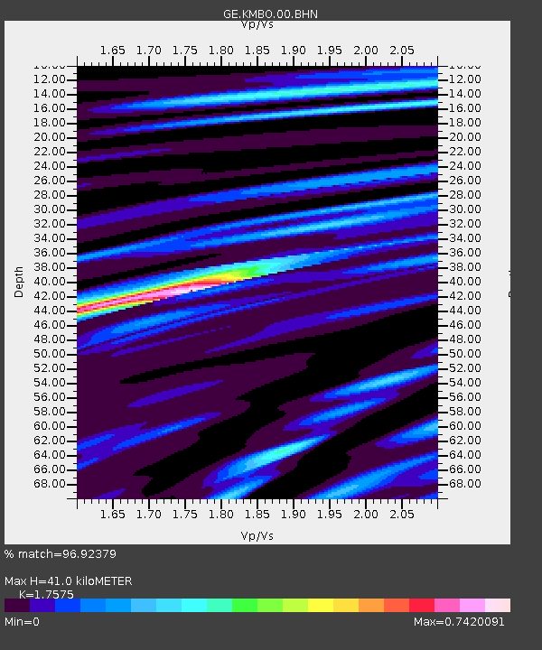
| Estimated Moho Depth: |
41.0 km |
| Estimated Crust Vp/Vs: |
1.76 |
| Assumed Crust Vp: |
6.601 km/s |
| Estimated Crust Vs: |
3.756 km/s |
| Estimated Crust Poisson's Ratio: |
0.26 |
|
| Radial Match: |
96.92379 % |
| Radial Bump: |
400 |
| Transverse Match: |
92.25681 % |
| Transverse Bump: |
400 |
| SOD ConfigId: |
2459 |
| Insert Time: |
2010-03-09 05:31:42.115 +0000 |
| GWidth: |
2.5 |
| Max Bumps: |
400 |
| Tol: |
0.001 |
|

Signal To Noise
| Channel | StoN | STA | LTA |
| GE:KMBO:00:BHN:20040423T02:02:29.647002Z | 3.2060616 | 1.6547708E-7 | 5.1613817E-8 |
| GE:KMBO:00:BHE:20040423T02:02:29.647002Z | 5.006824 | 3.9807765E-7 | 7.950702E-8 |
| GE:KMBO:00:BHZ:20040423T02:02:29.647002Z | 12.279093 | 1.1844287E-6 | 9.645897E-8 |
| Arrivals |
| Ps | 4.8 SECOND |
| PpPs | 17 SECOND |
| PsPs/PpSs | 22 SECOND |


