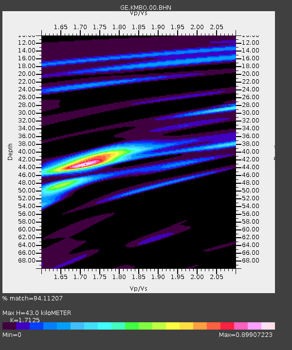
KMBO IRIS/GEOFON Station Kilima Mbogo, Kenya - Earthquake Result Viewer

Earthquake location: Northern Sumatra, Indonesia
Earthquake latitude/longitude: 0.4/97.8
Earthquake time(UTC): 2004/05/11 (132) 08:28:48 GMT
Earthquake Depth: 21 km
Earthquake Magnitude: 5.6 MB, 6.2 MS, 6.1 MW, 6.1 MW
Earthquake Catalog/Contributor: WHDF/NEIC
Network: GE GEOFON
Station: KMBO IRIS/GEOFON Station Kilima Mbogo, Kenya
Lat/Lon: 1.13 S/37.25 E
Elevation: 1940 m
Distance: 60.6 deg
Az: 268.483 deg
Baz: 88.896 deg
Ray Param: 0.061407268
Estimated Moho Depth: 43.0 km
Estimated Crust Vp/Vs: 1.71
Assumed Crust Vp: 6.601 km/s
Estimated Crust Vs: 3.854 km/s
Estimated Crust Poisson's Ratio: 0.24
Radial Match: 94.11207 %
Radial Bump: 334
Transverse Match: 67.766884 %
Transverse Bump: 400
SOD ConfigId: 2459
Insert Time: 2010-03-09 05:31:43.350 +0000
GWidth: 2.5
Max Bumps: 400
Tol: 0.001

Signal To Noise

ChannelStoNSTALTA
GE:KMBO:00:BHN:20040511T08:38:26.248018Z0.59220974.0192162E-86.786813E-8
GE:KMBO:00:BHE:20040511T08:38:26.248018Z2.19723949.9988725E-84.5506525E-8
GE:KMBO:00:BHZ:20040511T08:38:26.248018Z4.2793022.148976E-75.0217906E-8
Arrivals
Ps4.9 SECOND
PpPs17 SECOND
PsPs/PpSs22 SECOND