You are here: Home > Network List > GE - GEOFON Stations List
> Station KMBO IRIS/GEOFON Station Kilima Mbogo, Kenya > Earthquake Result Viewer
KMBO IRIS/GEOFON Station Kilima Mbogo, Kenya - Earthquake Result Viewer
| Earthquake location: |
Minahassa Peninsula, Sulawesi |
| Earthquake latitude/longitude: |
0.8/124.7 |
| Earthquake time(UTC): |
2004/06/30 (182) 23:37:25 GMT |
| Earthquake Depth: |
91 km |
| Earthquake Magnitude: |
6.0 MB, 6.3 MW, 6.2 MW |
| Earthquake Catalog/Contributor: |
WHDF/NEIC |
|
| Network: |
GE GEOFON |
| Station: |
KMBO IRIS/GEOFON Station Kilima Mbogo, Kenya |
| Lat/Lon: |
1.13 S/37.25 E |
| Elevation: |
1940 m |
|
| Distance: |
87.5 deg |
| Az: |
268.845 deg |
| Baz: |
89.158 deg |
| Ray Param: |
0.043103665 |
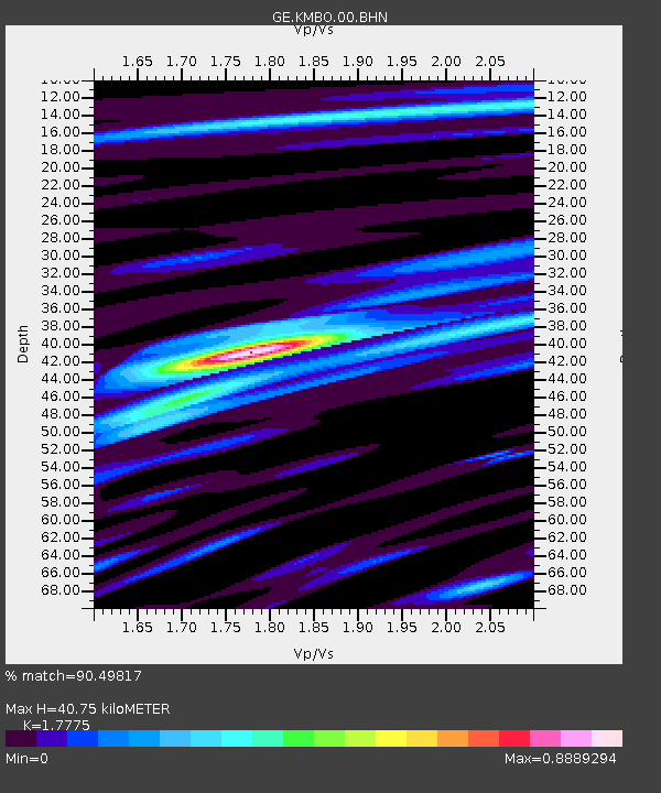
| Estimated Moho Depth: |
40.75 km |
| Estimated Crust Vp/Vs: |
1.78 |
| Assumed Crust Vp: |
6.601 km/s |
| Estimated Crust Vs: |
3.713 km/s |
| Estimated Crust Poisson's Ratio: |
0.27 |
|
| Radial Match: |
90.49817 % |
| Radial Bump: |
400 |
| Transverse Match: |
70.25411 % |
| Transverse Bump: |
400 |
| SOD ConfigId: |
2459 |
| Insert Time: |
2010-03-09 05:31:44.559 +0000 |
| GWidth: |
2.5 |
| Max Bumps: |
400 |
| Tol: |
0.001 |
|

Signal To Noise
| Channel | StoN | STA | LTA |
| GE:KMBO:00:BHN:20040630T23:49:31.84801Z | 3.2726576 | 3.2812468E-7 | 1.0026246E-7 |
| GE:KMBO:00:BHE:20040630T23:49:31.84801Z | 13.527717 | 7.210562E-7 | 5.3302138E-8 |
| GE:KMBO:00:BHZ:20040630T23:49:31.84801Z | 33.51756 | 2.4530266E-6 | 7.318631E-8 |
| Arrivals |
| Ps | 4.9 SECOND |
| PpPs | 17 SECOND |
| PsPs/PpSs | 22 SECOND |


