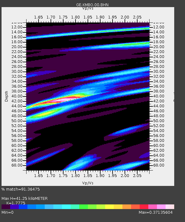
KMBO IRIS/GEOFON Station Kilima Mbogo, Kenya - Earthquake Result Viewer

Earthquake location: Irian Jaya Region, Indonesia
Earthquake latitude/longitude: -3.6/135.4
Earthquake time(UTC): 2004/11/26 (331) 02:25:03 GMT
Earthquake Depth: 10 km
Earthquake Magnitude: 6.2 MB, 7.2 MS, 7.1 MW, 7.0 MW
Earthquake Catalog/Contributor: WHDF/NEIC
Network: GE GEOFON
Station: KMBO IRIS/GEOFON Station Kilima Mbogo, Kenya
Lat/Lon: 1.13 S/37.25 E
Elevation: 1940 m
Distance: 98.1 deg
Az: 268.359 deg
Baz: 93.78 deg
Ray Param: 0.040020507
Estimated Moho Depth: 41.25 km
Estimated Crust Vp/Vs: 1.78
Assumed Crust Vp: 6.601 km/s
Estimated Crust Vs: 3.713 km/s
Estimated Crust Poisson's Ratio: 0.27
Radial Match: 91.36475 %
Radial Bump: 294
Transverse Match: 71.29361 %
Transverse Bump: 400
SOD ConfigId: 2459
Insert Time: 2010-03-09 05:31:57.301 +0000
GWidth: 2.5
Max Bumps: 400
Tol: 0.001

Signal To Noise

ChannelStoNSTALTA
GE:KMBO:00:BHN:20041126T02:38:08.060Z1.09554472.8347772E-82.5875506E-8
GE:KMBO:00:BHE:20041126T02:38:08.060Z0.705084743.588432E-85.0893625E-8
GE:KMBO:00:BHZ:20041126T02:38:08.060Z4.7015813.3013106E-77.0217034E-8
Arrivals
Ps5.0 SECOND
PpPs17 SECOND
PsPs/PpSs22 SECOND