You are here: Home > Network List > US - United States National Seismic Network Stations List
> Station OGNE Ogallala, Nebraska, USA > Earthquake Result Viewer
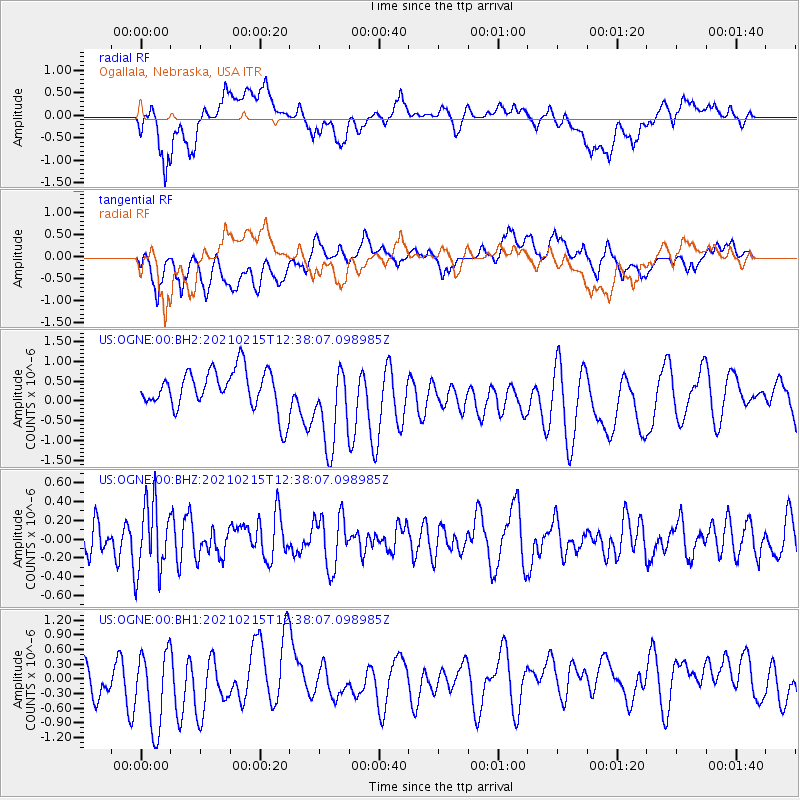
OGNE Ogallala, Nebraska, USA - Earthquake Result Viewer
*The percent match for this event was below the threshold and hence no stack was calculated.
| Earthquake location: |
Near East Coast Of Honshu, Japan |
| Earthquake latitude/longitude: |
37.5/141.4 |
| Earthquake time(UTC): |
2021/02/15 (046) 12:26:18 GMT |
| Earthquake Depth: |
40 km |
| Earthquake Magnitude: |
5.3 Mww |
| Earthquake Catalog/Contributor: |
NEIC PDE/us |
|
| Network: |
US United States National Seismic Network |
| Station: |
OGNE Ogallala, Nebraska, USA |
| Lat/Lon: |
40.95 N/102.03 W |
| Elevation: |
1054 m |
|
| Distance: |
82.7 deg |
| Az: |
43.075 deg |
| Baz: |
314.216 deg |
| Ray Param: |
$rayparam |
*The percent match for this event was below the threshold and hence was not used in the summary stack. |
|
| Radial Match: |
56.04033 % |
| Radial Bump: |
400 |
| Transverse Match: |
44.926323 % |
| Transverse Bump: |
400 |
| SOD ConfigId: |
23341671 |
| Insert Time: |
2021-03-01 14:07:08.755 +0000 |
| GWidth: |
2.5 |
| Max Bumps: |
400 |
| Tol: |
0.001 |
|
Signal To Noise
| Channel | StoN | STA | LTA |
| US:OGNE:00:BHZ:20210215T12:38:07.098985Z | 2.0433621 | 3.7440387E-7 | 1.8322933E-7 |
| US:OGNE:00:BH1:20210215T12:38:07.098985Z | 1.2037928 | 9.250047E-7 | 7.6840854E-7 |
| US:OGNE:00:BH2:20210215T12:38:07.098985Z | 2.0936863 | 1.0519192E-6 | 5.024244E-7 |
| Arrivals |
| Ps | |
| PpPs | |
| PsPs/PpSs | |


