You are here: Home > Network List > US - United States National Seismic Network Stations List
> Station SCIA State Center, Iowa, USA > Earthquake Result Viewer
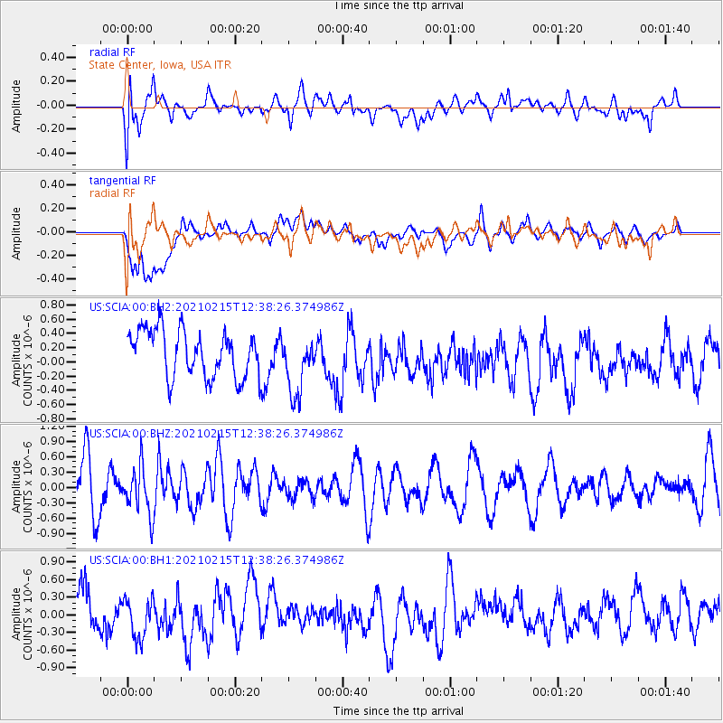
SCIA State Center, Iowa, USA - Earthquake Result Viewer
*The percent match for this event was below the threshold and hence no stack was calculated.
| Earthquake location: |
Near East Coast Of Honshu, Japan |
| Earthquake latitude/longitude: |
37.5/141.4 |
| Earthquake time(UTC): |
2021/02/15 (046) 12:26:18 GMT |
| Earthquake Depth: |
40 km |
| Earthquake Magnitude: |
5.3 Mww |
| Earthquake Catalog/Contributor: |
NEIC PDE/us |
|
| Network: |
US United States National Seismic Network |
| Station: |
SCIA State Center, Iowa, USA |
| Lat/Lon: |
41.91 N/93.22 W |
| Elevation: |
312 m |
|
| Distance: |
86.6 deg |
| Az: |
37.56 deg |
| Baz: |
319.519 deg |
| Ray Param: |
$rayparam |
*The percent match for this event was below the threshold and hence was not used in the summary stack. |
|
| Radial Match: |
59.246567 % |
| Radial Bump: |
400 |
| Transverse Match: |
57.22234 % |
| Transverse Bump: |
400 |
| SOD ConfigId: |
23341671 |
| Insert Time: |
2021-03-01 14:07:11.738 +0000 |
| GWidth: |
2.5 |
| Max Bumps: |
400 |
| Tol: |
0.001 |
|
Signal To Noise
| Channel | StoN | STA | LTA |
| US:SCIA:00:BHZ:20210215T12:38:26.374986Z | 0.94512725 | 4.7230688E-7 | 4.9972834E-7 |
| US:SCIA:00:BH1:20210215T12:38:26.374986Z | 0.95996416 | 3.759531E-7 | 3.9163245E-7 |
| US:SCIA:00:BH2:20210215T12:38:26.374986Z | 1.3133848 | 4.3056997E-7 | 3.278323E-7 |
| Arrivals |
| Ps | |
| PpPs | |
| PsPs/PpSs | |


