You are here: Home > Network List > US - United States National Seismic Network Stations List
> Station TPNV Topopah Spring, Nevada, USA > Earthquake Result Viewer
TPNV Topopah Spring, Nevada, USA - Earthquake Result Viewer
*The percent match for this event was below the threshold and hence no stack was calculated.
| Earthquake location: |
Near East Coast Of Honshu, Japan |
| Earthquake latitude/longitude: |
37.5/141.4 |
| Earthquake time(UTC): |
2021/02/15 (046) 12:26:18 GMT |
| Earthquake Depth: |
40 km |
| Earthquake Magnitude: |
5.3 Mww |
| Earthquake Catalog/Contributor: |
NEIC PDE/us |
|
| Network: |
US United States National Seismic Network |
| Station: |
TPNV Topopah Spring, Nevada, USA |
| Lat/Lon: |
36.95 N/116.25 W |
| Elevation: |
1600 m |
|
| Distance: |
76.9 deg |
| Az: |
53.462 deg |
| Baz: |
307.128 deg |
| Ray Param: |
$rayparam |
*The percent match for this event was below the threshold and hence was not used in the summary stack. |
|
| Radial Match: |
60.859028 % |
| Radial Bump: |
400 |
| Transverse Match: |
59.103783 % |
| Transverse Bump: |
400 |
| SOD ConfigId: |
23341671 |
| Insert Time: |
2021-03-01 14:07:12.342 +0000 |
| GWidth: |
2.5 |
| Max Bumps: |
400 |
| Tol: |
0.001 |
|
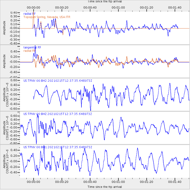
Signal To Noise
| Channel | StoN | STA | LTA |
| US:TPNV:00:BHZ:20210215T12:37:35.648973Z | 2.1294 | 3.949812E-7 | 1.8548943E-7 |
| US:TPNV:00:BH1:20210215T12:37:35.648973Z | 1.5560989 | 2.4647838E-7 | 1.5839507E-7 |
| US:TPNV:00:BH2:20210215T12:37:35.648973Z | 1.0814974 | 1.9567189E-7 | 1.8092682E-7 |
| Arrivals |
| Ps | |
| PpPs | |
| PsPs/PpSs | |


