You are here: Home > Network List > WY - Yellowstone Wyoming Seismic Network Stations List
> Station YEE East Entrance, YNP, WY, USA > Earthquake Result Viewer
YEE East Entrance, YNP, WY, USA - Earthquake Result Viewer
| Earthquake location: |
Near East Coast Of Honshu, Japan |
| Earthquake latitude/longitude: |
37.5/141.4 |
| Earthquake time(UTC): |
2021/02/15 (046) 12:26:18 GMT |
| Earthquake Depth: |
40 km |
| Earthquake Magnitude: |
5.3 Mww |
| Earthquake Catalog/Contributor: |
NEIC PDE/us |
|
| Network: |
WY Yellowstone Wyoming Seismic Network |
| Station: |
YEE East Entrance, YNP, WY, USA |
| Lat/Lon: |
44.49 N/109.90 W |
| Elevation: |
2270 m |
|
| Distance: |
76.0 deg |
| Az: |
44.31 deg |
| Baz: |
309.122 deg |
| Ray Param: |
0.05119175 |
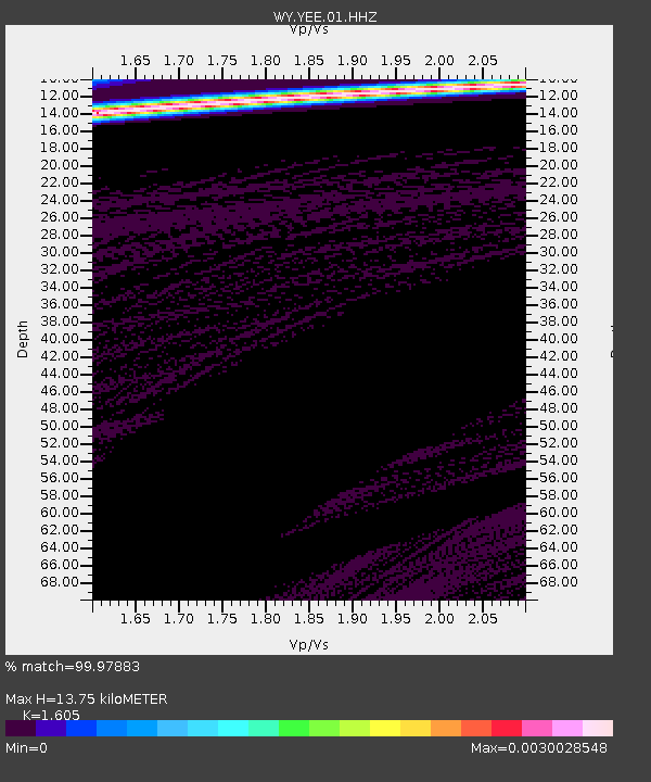
| Estimated Moho Depth: |
13.75 km |
| Estimated Crust Vp/Vs: |
1.61 |
| Assumed Crust Vp: |
6.242 km/s |
| Estimated Crust Vs: |
3.889 km/s |
| Estimated Crust Poisson's Ratio: |
0.18 |
|
| Radial Match: |
99.97883 % |
| Radial Bump: |
4 |
| Transverse Match: |
99.99888 % |
| Transverse Bump: |
2 |
| SOD ConfigId: |
23341671 |
| Insert Time: |
2021-03-01 14:08:37.120 +0000 |
| GWidth: |
2.5 |
| Max Bumps: |
400 |
| Tol: |
0.001 |
|

Signal To Noise
| Channel | StoN | STA | LTA |
| WY:YEE:01:HHZ:20210215T12:37:30.890001Z | 2.2414129 | 6.3282135E-7 | 2.8233146E-7 |
| WY:YEE:01:HHN:20210215T12:37:30.890001Z | 2.197398 | 1.5764799E-7 | 7.174303E-8 |
| WY:YEE:01:HHE:20210215T12:37:30.890001Z | 2.2694163 | 6.257615E-7 | 2.7573677E-7 |
| Arrivals |
| Ps | 1.4 SECOND |
| PpPs | 5.6 SECOND |
| PsPs/PpSs | 6.9 SECOND |


