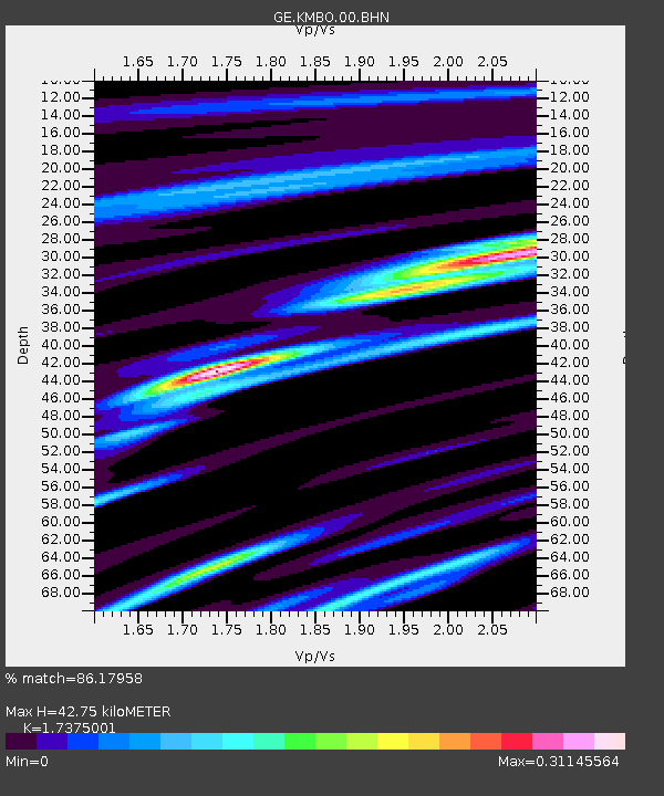
KMBO IRIS/GEOFON Station Kilima Mbogo, Kenya - Earthquake Result Viewer

Earthquake location: Nicobar Islands, India Region
Earthquake latitude/longitude: 8.1/94.1
Earthquake time(UTC): 2005/02/06 (037) 06:07:55 GMT
Earthquake Depth: 18 km
Earthquake Magnitude: 5.4 MB, 5.1 MS, 5.5 MW, 5.4 MW
Earthquake Catalog/Contributor: WHDF/NEIC
Network: GE GEOFON
Station: KMBO IRIS/GEOFON Station Kilima Mbogo, Kenya
Lat/Lon: 1.13 S/37.25 E
Elevation: 1940 m
Distance: 57.4 deg
Az: 263.477 deg
Baz: 79.738 deg
Ray Param: 0.06351628
Estimated Moho Depth: 42.75 km
Estimated Crust Vp/Vs: 1.74
Assumed Crust Vp: 6.601 km/s
Estimated Crust Vs: 3.799 km/s
Estimated Crust Poisson's Ratio: 0.25
Radial Match: 86.17958 %
Radial Bump: 400
Transverse Match: 51.8876 %
Transverse Bump: 400
SOD ConfigId: 5233
Insert Time: 2010-03-09 05:32:17.184 +0000
GWidth: 2.5
Max Bumps: 400
Tol: 0.001

Signal To Noise

ChannelStoNSTALTA
GE:KMBO:00:BHN:20050206T06:17:11.17303Z1.09498065.791668E-85.2892883E-8
GE:KMBO:00:BHE:20050206T06:17:11.17303Z0.749924664.3432006E-85.7915162E-8
GE:KMBO:00:BHZ:20050206T06:17:11.17303Z1.36797631.10188964E-78.054889E-8
Arrivals
Ps5.0 SECOND
PpPs17 SECOND
PsPs/PpSs22 SECOND