You are here: Home > Network List > AK - Alaska Regional Network Stations List
> Station L18K Granite Mountain, AK, USA > Earthquake Result Viewer
L18K Granite Mountain, AK, USA - Earthquake Result Viewer
| Earthquake location: |
Vanuatu Islands |
| Earthquake latitude/longitude: |
-17.8/167.5 |
| Earthquake time(UTC): |
2021/02/16 (047) 00:49:26 GMT |
| Earthquake Depth: |
10 km |
| Earthquake Magnitude: |
6.2 Mww |
| Earthquake Catalog/Contributor: |
NEIC PDE/us |
|
| Network: |
AK Alaska Regional Network |
| Station: |
L18K Granite Mountain, AK, USA |
| Lat/Lon: |
62.22 N/156.69 W |
| Elevation: |
329 m |
|
| Distance: |
84.6 deg |
| Az: |
15.996 deg |
| Baz: |
214.077 deg |
| Ray Param: |
0.045337312 |
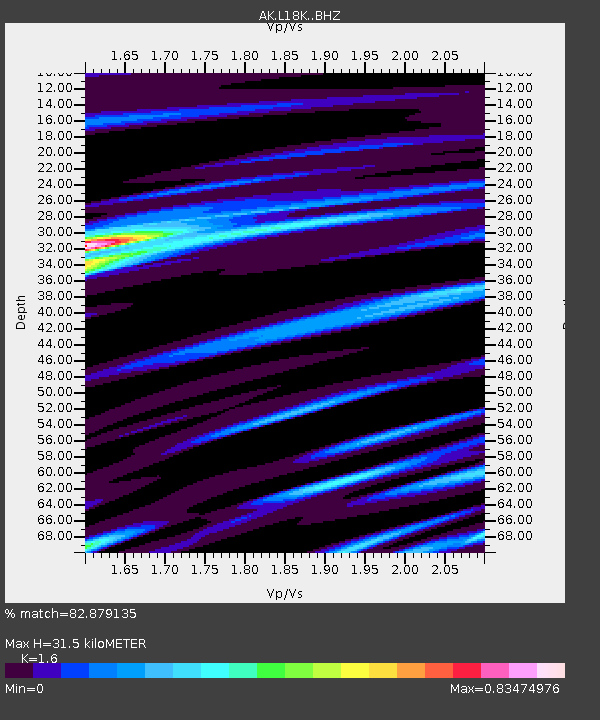
| Estimated Moho Depth: |
31.5 km |
| Estimated Crust Vp/Vs: |
1.60 |
| Assumed Crust Vp: |
6.182 km/s |
| Estimated Crust Vs: |
3.864 km/s |
| Estimated Crust Poisson's Ratio: |
0.18 |
|
| Radial Match: |
82.879135 % |
| Radial Bump: |
400 |
| Transverse Match: |
56.274372 % |
| Transverse Bump: |
400 |
| SOD ConfigId: |
23341671 |
| Insert Time: |
2021-03-02 01:52:35.312 +0000 |
| GWidth: |
2.5 |
| Max Bumps: |
400 |
| Tol: |
0.001 |
|

Signal To Noise
| Channel | StoN | STA | LTA |
| AK:L18K: :BHZ:20210216T01:01:28.380028Z | 7.1032605 | 2.6774765E-6 | 3.7693627E-7 |
| AK:L18K: :BHN:20210216T01:01:28.380028Z | 3.2923896 | 8.460752E-7 | 2.5697906E-7 |
| AK:L18K: :BHE:20210216T01:01:28.380028Z | 1.9561987 | 6.2291014E-7 | 3.1842887E-7 |
| Arrivals |
| Ps | 3.1 SECOND |
| PpPs | 13 SECOND |
| PsPs/PpSs | 16 SECOND |


