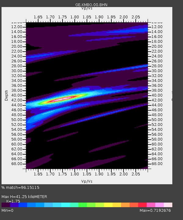
KMBO IRIS/GEOFON Station Kilima Mbogo, Kenya - Earthquake Result Viewer

Earthquake location: Northern Sumatra, Indonesia
Earthquake latitude/longitude: 2.0/97.9
Earthquake time(UTC): 2005/04/03 (093) 03:10:56 GMT
Earthquake Depth: 36 km
Earthquake Magnitude: 6.0 MB, 5.9 MS, 6.3 MW, 6.3 MW
Earthquake Catalog/Contributor: WHDF/NEIC
Network: GE GEOFON
Station: KMBO IRIS/GEOFON Station Kilima Mbogo, Kenya
Lat/Lon: 1.13 S/37.25 E
Elevation: 1940 m
Distance: 60.8 deg
Az: 267.591 deg
Baz: 87.07 deg
Ray Param: 0.06125397
Estimated Moho Depth: 41.25 km
Estimated Crust Vp/Vs: 1.75
Assumed Crust Vp: 6.601 km/s
Estimated Crust Vs: 3.772 km/s
Estimated Crust Poisson's Ratio: 0.26
Radial Match: 96.15115 %
Radial Bump: 253
Transverse Match: 80.097755 %
Transverse Bump: 400
SOD ConfigId: 2459
Insert Time: 2010-03-09 05:32:32.273 +0000
GWidth: 2.5
Max Bumps: 400
Tol: 0.001

Signal To Noise

ChannelStoNSTALTA
GE:KMBO:00:BHN:20050403T03:20:33.910002Z0.76257773.4092174E-84.4706493E-8
GE:KMBO:00:BHE:20050403T03:20:33.910002Z1.8041738.1911324E-84.5401038E-8
GE:KMBO:00:BHZ:20050403T03:20:33.910002Z2.51020723.49207E-71.3911482E-7
Arrivals
Ps4.9 SECOND
PpPs16 SECOND
PsPs/PpSs21 SECOND