You are here: Home > Network List > UU - University of Utah Regional Network Stations List
> Station CCUT Cedar City, UT, USA > Earthquake Result Viewer
CCUT Cedar City, UT, USA - Earthquake Result Viewer
| Earthquake location: |
Northern Chile |
| Earthquake latitude/longitude: |
-18.5/-69.6 |
| Earthquake time(UTC): |
2017/10/10 (283) 06:32:20 GMT |
| Earthquake Depth: |
82 km |
| Earthquake Magnitude: |
6.3 Mww |
| Earthquake Catalog/Contributor: |
NEIC PDE/us |
|
| Network: |
UU University of Utah Regional Network |
| Station: |
CCUT Cedar City, UT, USA |
| Lat/Lon: |
37.55 N/113.36 W |
| Elevation: |
2127 m |
|
| Distance: |
69.3 deg |
| Az: |
324.041 deg |
| Baz: |
135.49 deg |
| Ray Param: |
0.0555361 |
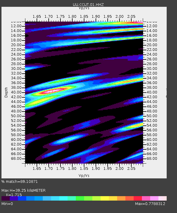
| Estimated Moho Depth: |
39.25 km |
| Estimated Crust Vp/Vs: |
1.72 |
| Assumed Crust Vp: |
6.194 km/s |
| Estimated Crust Vs: |
3.612 km/s |
| Estimated Crust Poisson's Ratio: |
0.24 |
|
| Radial Match: |
89.10871 % |
| Radial Bump: |
351 |
| Transverse Match: |
77.19962 % |
| Transverse Bump: |
352 |
| SOD ConfigId: |
2364251 |
| Insert Time: |
2017-10-24 06:39:32.995 +0000 |
| GWidth: |
2.5 |
| Max Bumps: |
400 |
| Tol: |
0.001 |
|

Signal To Noise
| Channel | StoN | STA | LTA |
| UU:CCUT:01:HHZ:20171010T06:42:48.459973Z | 3.8948166 | 1.4565567E-6 | 3.739731E-7 |
| UU:CCUT:01:HHN:20171010T06:42:48.459973Z | 1.2352085 | 3.579388E-7 | 2.8978008E-7 |
| UU:CCUT:01:HHE:20171010T06:42:48.459973Z | 2.81826 | 4.7316814E-7 | 1.6789372E-7 |
| Arrivals |
| Ps | 4.7 SECOND |
| PpPs | 17 SECOND |
| PsPs/PpSs | 21 SECOND |


