You are here: Home > Network List > UU - University of Utah Regional Network Stations List
> Station FORU South Mineral Mountains, UT, USA > Earthquake Result Viewer
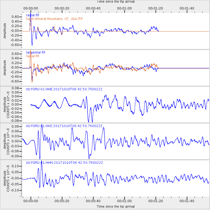
FORU South Mineral Mountains, UT, USA - Earthquake Result Viewer
*The percent match for this event was below the threshold and hence no stack was calculated.
| Earthquake location: |
Northern Chile |
| Earthquake latitude/longitude: |
-18.5/-69.6 |
| Earthquake time(UTC): |
2017/10/10 (283) 06:32:20 GMT |
| Earthquake Depth: |
82 km |
| Earthquake Magnitude: |
6.3 Mww |
| Earthquake Catalog/Contributor: |
NEIC PDE/us |
|
| Network: |
UU University of Utah Regional Network |
| Station: |
FORU South Mineral Mountains, UT, USA |
| Lat/Lon: |
38.46 N/112.86 W |
| Elevation: |
1840 m |
|
| Distance: |
69.7 deg |
| Az: |
325.019 deg |
| Baz: |
136.14 deg |
| Ray Param: |
$rayparam |
*The percent match for this event was below the threshold and hence was not used in the summary stack. |
|
| Radial Match: |
75.325226 % |
| Radial Bump: |
400 |
| Transverse Match: |
63.199375 % |
| Transverse Bump: |
400 |
| SOD ConfigId: |
2364251 |
| Insert Time: |
2017-10-24 06:39:44.420 +0000 |
| GWidth: |
2.5 |
| Max Bumps: |
400 |
| Tol: |
0.001 |
|
Signal To Noise
| Channel | StoN | STA | LTA |
| UU:FORU:01:HHZ:20171010T06:42:50.760022Z | 3.1782799 | 3.303888E-8 | 1.0395208E-8 |
| UU:FORU:01:HHN:20171010T06:42:50.760022Z | 1.4060357 | 2.4090472E-8 | 1.7133614E-8 |
| UU:FORU:01:HHE:20171010T06:42:50.760022Z | 0.8272623 | 1.158988E-8 | 1.4009922E-8 |
| Arrivals |
| Ps | |
| PpPs | |
| PsPs/PpSs | |


