You are here: Home > Network List > XW97 - Tien Shan Continental Dynamics Stations List
> Station BCHU XW.BCHU > Earthquake Result Viewer
BCHU XW.BCHU - Earthquake Result Viewer

| Earthquake location: |
Halmahera, Indonesia |
| Earthquake latitude/longitude: |
2.9/128.6 |
| Earthquake time(UTC): |
1998/10/27 (300) 21:16:21 GMT |
| Earthquake Depth: |
61 km |
| Earthquake Magnitude: |
5.9 MB, 5.9 UNKNOWN, 5.9 MW |
| Earthquake Catalog/Contributor: |
WHDF/NEIC |
|
| Network: |
XW Tien Shan Continental Dynamics |
| Station: |
BCHU XW.BCHU |
| Lat/Lon: |
39.79 N/78.78 E |
| Elevation: |
1140 m |
|
| Distance: |
58.1 deg |
| Az: |
316.082 deg |
| Baz: |
115.959 deg |
| Ray Param: |
0.06291445 |
| Estimated Moho Depth: |
13.0 km |
| Estimated Crust Vp/Vs: |
2.09 |
| Assumed Crust Vp: |
6.242 km/s |
| Estimated Crust Vs: |
2.994 km/s |
| Estimated Crust Poisson's Ratio: |
0.35 |
|
| Radial Match: |
93.65823 % |
| Radial Bump: |
400 |
| Transverse Match: |
79.50567 % |
| Transverse Bump: |
400 |
| SOD ConfigId: |
4480 |
| Insert Time: |
2010-02-26 15:18:58.163 +0000 |
| GWidth: |
2.5 |
| Max Bumps: |
400 |
| Tol: |
0.001 |
|
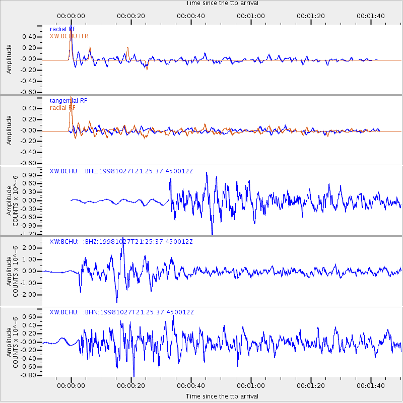
Signal To Noise
| Channel | StoN | STA | LTA |
| XW:BCHU: :BHZ:19981027T21:25:37.450012Z | 10.048786 | 5.4433747E-7 | 5.4169476E-8 |
| XW:BCHU: :BHN:19981027T21:25:37.450012Z | 2.9931467 | 1.2357106E-7 | 4.1284665E-8 |
| XW:BCHU: :BHE:19981027T21:25:37.450012Z | 5.7403407 | 2.9343016E-7 | 5.11172E-8 |
| Arrivals |
| Ps | 2.3 SECOND |
| PpPs | 6.2 SECOND |
| PsPs/PpSs | 8.5 SECOND |


