You are here: Home > Network List > NN - Western Great Basin/Eastern Sierra Nevada Stations List
> Station ZPR Zephyr Cove, Lake Tahoe, Nevada > Earthquake Result Viewer
ZPR Zephyr Cove, Lake Tahoe, Nevada - Earthquake Result Viewer
| Earthquake location: |
Vanuatu Islands |
| Earthquake latitude/longitude: |
-17.8/167.5 |
| Earthquake time(UTC): |
2021/02/16 (047) 00:49:26 GMT |
| Earthquake Depth: |
10 km |
| Earthquake Magnitude: |
6.2 Mww |
| Earthquake Catalog/Contributor: |
NEIC PDE/us |
|
| Network: |
NN Western Great Basin/Eastern Sierra Nevada |
| Station: |
ZPR Zephyr Cove, Lake Tahoe, Nevada |
| Lat/Lon: |
39.01 N/119.94 W |
| Elevation: |
2001 m |
|
| Distance: |
88.2 deg |
| Az: |
48.053 deg |
| Baz: |
245.437 deg |
| Ray Param: |
0.042766478 |
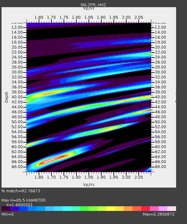
| Estimated Moho Depth: |
65.5 km |
| Estimated Crust Vp/Vs: |
1.69 |
| Assumed Crust Vp: |
6.279 km/s |
| Estimated Crust Vs: |
3.726 km/s |
| Estimated Crust Poisson's Ratio: |
0.23 |
|
| Radial Match: |
92.76673 % |
| Radial Bump: |
245 |
| Transverse Match: |
99.70829 % |
| Transverse Bump: |
54 |
| SOD ConfigId: |
23341671 |
| Insert Time: |
2021-03-02 02:05:11.199 +0000 |
| GWidth: |
2.5 |
| Max Bumps: |
400 |
| Tol: |
0.001 |
|

Signal To Noise
| Channel | StoN | STA | LTA |
| NN:ZPR: :HHZ:20210216T01:01:45.737999Z | 4.147423 | 5.9470995E-7 | 1.4339265E-7 |
| NN:ZPR: :HHN:20210216T01:01:45.737999Z | 4.071839 | 7.76425E-7 | 1.9068166E-7 |
| NN:ZPR: :HHE:20210216T01:01:45.737999Z | 1.1682025 | 1.2838056E-7 | 1.09895815E-7 |
| Arrivals |
| Ps | 7.3 SECOND |
| PpPs | 27 SECOND |
| PsPs/PpSs | 35 SECOND |


