You are here: Home > Network List > NN - Western Great Basin/Eastern Sierra Nevada Stations List
> Station MCM07 Monte Cristo Menlo 07 > Earthquake Result Viewer
MCM07 Monte Cristo Menlo 07 - Earthquake Result Viewer
| Earthquake location: |
Vanuatu Islands |
| Earthquake latitude/longitude: |
-17.8/167.5 |
| Earthquake time(UTC): |
2021/02/16 (047) 00:49:26 GMT |
| Earthquake Depth: |
10 km |
| Earthquake Magnitude: |
6.2 Mww |
| Earthquake Catalog/Contributor: |
NEIC PDE/us |
|
| Network: |
NN Western Great Basin/Eastern Sierra Nevada |
| Station: |
MCM07 Monte Cristo Menlo 07 |
| Lat/Lon: |
38.23 N/117.75 W |
| Elevation: |
1716 m |
|
| Distance: |
89.5 deg |
| Az: |
49.465 deg |
| Baz: |
246.828 deg |
| Ray Param: |
0.041842666 |
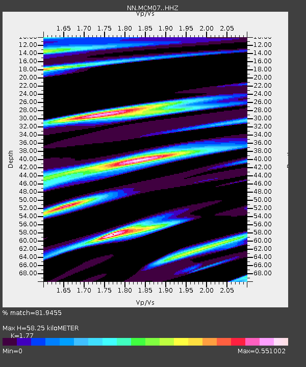
| Estimated Moho Depth: |
58.25 km |
| Estimated Crust Vp/Vs: |
1.77 |
| Assumed Crust Vp: |
6.276 km/s |
| Estimated Crust Vs: |
3.546 km/s |
| Estimated Crust Poisson's Ratio: |
0.27 |
|
| Radial Match: |
81.9455 % |
| Radial Bump: |
400 |
| Transverse Match: |
82.33716 % |
| Transverse Bump: |
400 |
| SOD ConfigId: |
23341671 |
| Insert Time: |
2021-03-02 02:05:14.239 +0000 |
| GWidth: |
2.5 |
| Max Bumps: |
400 |
| Tol: |
0.001 |
|

Signal To Noise
| Channel | StoN | STA | LTA |
| NN:MCM07: :HHZ:20210216T01:01:51.615013Z | 7.342172 | 1.8091532E-6 | 2.4640573E-7 |
| NN:MCM07: :HHN:20210216T01:01:51.615013Z | 0.8478672 | 2.2184592E-7 | 2.6165173E-7 |
| NN:MCM07: :HHE:20210216T01:01:51.615013Z | 2.8939755 | 6.4650936E-7 | 2.2339835E-7 |
| Arrivals |
| Ps | 7.3 SECOND |
| PpPs | 25 SECOND |
| PsPs/PpSs | 32 SECOND |


