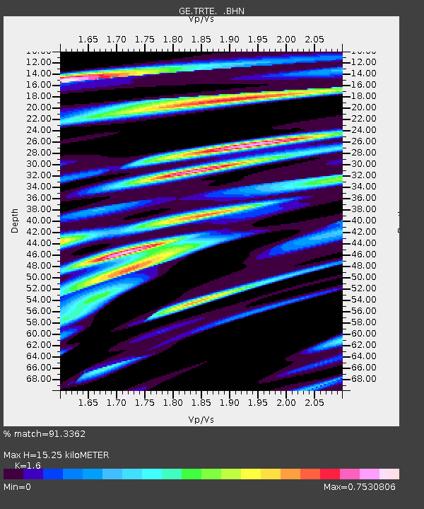
TRTE GEOFON Station Tartu, Estonia - Earthquake Result Viewer

Earthquake location: Northern And Central Iran
Earthquake latitude/longitude: 33.8/59.8
Earthquake time(UTC): 1997/05/10 (130) 07:57:29 GMT
Earthquake Depth: 10 km
Earthquake Magnitude: 6.4 MB, 7.3 MS, 7.5 UNKNOWN, 7.2 MW
Earthquake Catalog/Contributor: WHDF/NEIC
Network: GE GEOFON
Station: TRTE GEOFON Station Tartu, Estonia
Lat/Lon: 58.38 N/26.72 E
Elevation: 0.0 m
Distance: 33.0 deg
Az: 328.149 deg
Baz: 123.507 deg
Ray Param: 0.078397214
Estimated Moho Depth: 15.25 km
Estimated Crust Vp/Vs: 1.60
Assumed Crust Vp: 6.552 km/s
Estimated Crust Vs: 4.095 km/s
Estimated Crust Poisson's Ratio: 0.18
Radial Match: 91.3362 %
Radial Bump: 400
Transverse Match: 63.74456 %
Transverse Bump: 400
SOD ConfigId: 6273
Insert Time: 2010-03-09 05:33:24.279 +0000
GWidth: 2.5
Max Bumps: 400
Tol: 0.001

Signal To Noise

ChannelStoNSTALTA
GE:TRTE: :BHN:19970510T08:03:34.353015Z1.2770451.5616656E-61.2228744E-6
GE:TRTE: :BHE:19970510T08:03:34.353015Z1.93645141.9799284E-61.0224519E-6
GE:TRTE: :BHZ:19970510T08:03:34.353015Z3.98366882.1618594E-65.4268054E-7
Arrivals
Ps1.5 SECOND
PpPs5.5 SECOND
PsPs/PpSs7.1 SECOND