You are here: Home > Network List > TA - USArray Transportable Network (new EarthScope stations) Stations List
> Station E20K Nigu River, AK, USA > Earthquake Result Viewer
E20K Nigu River, AK, USA - Earthquake Result Viewer
| Earthquake location: |
Vanuatu Islands |
| Earthquake latitude/longitude: |
-17.8/167.5 |
| Earthquake time(UTC): |
2021/02/16 (047) 00:49:26 GMT |
| Earthquake Depth: |
10 km |
| Earthquake Magnitude: |
6.2 Mww |
| Earthquake Catalog/Contributor: |
NEIC PDE/us |
|
| Network: |
TA USArray Transportable Network (new EarthScope stations) |
| Station: |
E20K Nigu River, AK, USA |
| Lat/Lon: |
68.26 N/156.19 W |
| Elevation: |
866 m |
|
| Distance: |
89.8 deg |
| Az: |
12.757 deg |
| Baz: |
214.374 deg |
| Ray Param: |
0.041731678 |
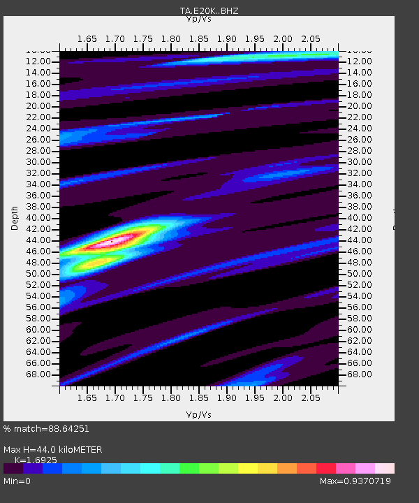
| Estimated Moho Depth: |
44.0 km |
| Estimated Crust Vp/Vs: |
1.69 |
| Assumed Crust Vp: |
6.221 km/s |
| Estimated Crust Vs: |
3.676 km/s |
| Estimated Crust Poisson's Ratio: |
0.23 |
|
| Radial Match: |
88.64251 % |
| Radial Bump: |
386 |
| Transverse Match: |
79.836395 % |
| Transverse Bump: |
400 |
| SOD ConfigId: |
23341671 |
| Insert Time: |
2021-03-02 02:07:01.499 +0000 |
| GWidth: |
2.5 |
| Max Bumps: |
400 |
| Tol: |
0.001 |
|

Signal To Noise
| Channel | StoN | STA | LTA |
| TA:E20K: :BHZ:20210216T01:01:53.149986Z | 12.216984 | 1.8788255E-6 | 1.53788E-7 |
| TA:E20K: :BHN:20210216T01:01:53.149986Z | 3.2789257 | 3.5696382E-7 | 1.088661E-7 |
| TA:E20K: :BHE:20210216T01:01:53.149986Z | 3.8088949 | 3.3694093E-7 | 8.84616E-8 |
| Arrivals |
| Ps | 5.0 SECOND |
| PpPs | 19 SECOND |
| PsPs/PpSs | 24 SECOND |


